Dive headfirst into the world of Aerial LiDAR (Light Detection and Ranging) with us – the game-changing remote sensing technology redefining the way we gather and interpret data about our Earth. An incredibly adaptable tool, it finds use in diverse sectors from environmental research and city planning to agriculture and law enforcement.
Key Takeaways
- LiDAR Technology Overview: LiDAR is a remote sensing method that measures distances using laser light, creating detailed 3D models of the Earth’s surface.
- Components of LiDAR Systems: LiDAR systems consist of a laser, scanner, GPS/IMU, and processing software, each playing a crucial role in data accuracy and interpretation.
- Types of LiDAR Systems: Airborne, terrestrial, and mobile LiDAR systems cater to various applications like topography, archaeology, and urban planning.
- LiDAR vs. Other Technologies: LiDAR offers higher accuracy and resolution compared to photogrammetry and radar, especially in complex environments.
- Future Trends in LiDAR: Expect advancements in miniaturization, accuracy, real-time processing, and integration with other technologies.
- Importance of Accuracy in LiDAR: Accurate LiDAR data is vital for reliable 3D modeling, influenced by system quality, platform stability, and atmospheric conditions.
Gaining Mastery over Aerial LiDAR
Our goal is to offer you a comprehensive grasp of Aerial LiDAR. We will delve into the essentials, distinctive kinds, applications, benefits, and constraints of this revolutionary technology. This guide stands as a priceless asset not just for experts but also for anyone intrigued by the technology and its potential ramifications on our planet.
Exploring the Nuts and Bolts of LiDAR Systems
In this piece, we’ll thoroughly investigate the mechanics of LiDAR systems, talking about the elements that constitute these potent devices and how they synergize to generate astonishingly precise maps and models. We’ll scrutinize the distinct variants of LiDAR systems, like airborne, terrestrial, and mobile systems, each with their specific advantages and applications.
Navigating the Landscape of Remote Sensing and Geospatial Data
By the culmination of this guide, you’ll possess a comprehensive comprehension of Aerial LiDAR, its multiple applications, and benefits, making you capable of confidently navigating the world of remote sensing and geospatial data. So, let’s embark on this exciting voyage into the captivating domain of Aerial LiDAR!
Our aim is to provide you with an in-depth understanding of Aerial LiDAR, covering the fundamentals, various types, applications, benefits, and limitations of this groundbreaking technology. This guide will serve as an invaluable resource for professionals in the field, as well as for those who are curious about the technology and its potential impact on our world.
Throughout this article, we will dive deep into the inner workings of LiDAR systems, discussing the components that make up these powerful tools and how they function together to create incredibly accurate and detailed maps and models. We will also examine the different types of LiDAR systems, including airborne, terrestrial, and mobile systems, and their unique advantages and applications.
By the end of this guide, you will have a comprehensive understanding of Aerial LiDAR and its many uses and benefits, making you well-equipped to navigate the world of remote sensing and geospatial data. So, let’s begin our journey into the fascinating realm of Aerial LiDAR!
What is LiDAR?
LiDAR, short for Light Detection and Ranging, is a remote sensing technology that uses laser light to measure distances and generate precise, detailed 3D models of the Earth’s surface. To understand the many benefits of this revolutionary technology, check out this article. LiDAR works by emitting laser pulses and measuring the time it takes for the pulses to return after bouncing off objects on the ground. By knowing the speed of light and the time it takes for the laser pulse to travel, the system can calculate the distance to the object with incredible accuracy. This process generates a “point cloud” of data that can be used to create detailed maps and 3D models. To dive deeper into how LiDAR works, you can read this informative piece.
Understanding LiDAR for Dummies
To simplify the concept of LiDAR, think of it as a high-tech “tape measure” that uses laser light to measure distances. It sends out thousands of laser pulses per second, and each pulse bounces off objects and returns to the LiDAR sensor. By analyzing the time it takes for the light to travel back and forth, the system calculates the distance to the object, creating a highly accurate and detailed representation of the Earth’s surface.
LiDAR’s Ability to See Through Vegetation
One of LiDAR’s most astonishing capabilities is its ability to see through dense foliage. This is possible because LiDAR uses a laser light wavelength that can penetrate small gaps between leaves and branches, allowing it to detect objects hidden beneath the vegetation. By collecting data from multiple laser pulses that make their way through the foliage, LiDAR systems can generate an accurate representation of the terrain hidden under the canopy. This ability to “unmask nature’s secrets” has numerous applications in fields such as archaeology, forestry, and environmental research. To learn more about LiDAR’s impressive ability to see through dense foliage, check out this fascinating article.
History of LiDAR
The development of LiDAR technology dates back to the 1960s, with its roots in the invention of the laser and the subsequent advancements in laser-based remote sensing. In this section, we’ll explore the history of LiDAR and its evolution over the years.
The concept of LiDAR (Light Detection and Ranging) originated from the principles of RADAR (Radio Detection and Ranging), which had been used for remote sensing and detection since the 1940s. The invention of the laser in 1960 paved the way for the development of laser-based remote sensing technologies, including LiDAR.
The first LiDAR system was developed in the early 1960s by Hughes Aircraft Company in the United States. This early LiDAR system was primarily used for atmospheric studies, measuring the density of various gases in the Earth’s atmosphere. In 1971, the Apollo 15 mission used a laser altimeter, a precursor to modern LiDAR systems, to map the lunar surface.
In the following decades, advancements in laser technology, computing power, and data processing capabilities led to significant improvements in LiDAR systems. Airborne LiDAR systems were developed in the 1980s, enabling large-scale topographic mapping and allowing for more accurate and detailed measurements of the Earth’s surface.
The 1990s and 2000s saw the development of terrestrial LiDAR systems, which enabled high-resolution scanning of objects and landscapes from a ground-based perspective. These systems found applications in various industries, including architecture, engineering, and construction.
The rise of autonomous vehicles and robotics in the 21st century has further accelerated the growth of LiDAR technology. Modern LiDAR systems have become smaller, more affordable, and more capable, allowing for widespread adoption across various industries and applications.
In summary, the history of LiDAR is marked by continuous innovation and technological advancements, making it a versatile and invaluable tool in today’s world. As the technology continues to evolve, we can expect LiDAR to play an even more significant role in various industries and applications. For more in depth information on LiDAR’s History, check out this article.
Decoding the Inner Workings of Aerial LiDAR Systems
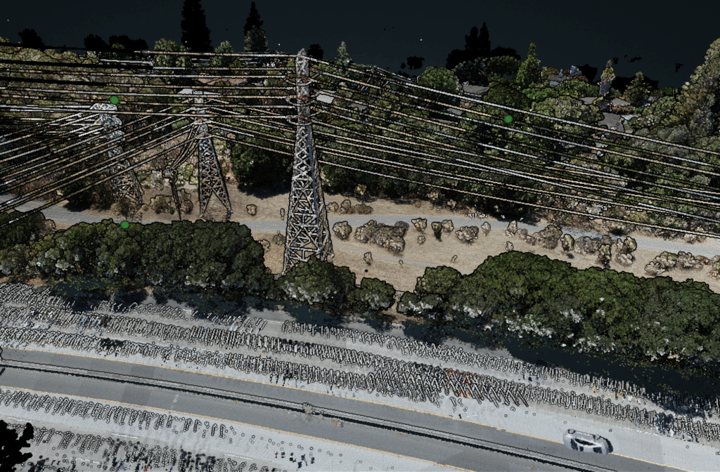
Aerial LiDAR systems function by emitting laser pulses towards the Earth’s surface from an airborne platform, such as a helicopter, fixed-wing aircraft, or drone. If you’re interested in unlocking the secrets of aerial LiDAR, you can read more about how it works in this article. These laser pulses subsequently interact with objects on the ground, reflecting off surfaces and returning to the LiDAR sensor. The system calculates the distance to the objects with high precision by measuring the time it takes for the pulses to travel to the ground and back. This process, referred to as time-of-flight measurement, is essential for obtaining accurate elevation data.
Key Components of Aerial LiDAR Data Collection
Laser pulse emission and reflection: Aerial LiDAR systems emit laser pulses that interact with ground objects, reflecting off surfaces and returning to the LiDAR sensor.
Time-of-flight measurement: The system calculates the distance to the objects by measuring the time it takes for the pulses to travel to the ground and back, resulting in accurate elevation data.
Intensity data capture: Aerial LiDAR systems also capture the intensity of the reflected laser pulses, providing valuable information about the properties of the surveyed objects, such as the type and density of vegetation or the characteristics of building materials.
Integrating GPS and IMU Data for Precise 3D Point Clouds
To generate a highly accurate 3D point cloud representing the surveyed area, the distance measurements are combined with the aircraft’s GPS and IMU (Inertial Measurement Unit) data.
- GPS data: Offers the precise location of the aircraft during the survey.
- IMU data: Monitors the aircraft’s orientation, encompassing its pitch, roll, and yaw angles.
These datasets, when combined, facilitate the accurate georeferencing and alignment of the LiDAR data, ultimately producing a detailed 3D representation of the Earth’s surface.
By understanding the functioning of aerial LiDAR systems, users can better appreciate the value of the technology in various applications and make informed decisions when employing LiDAR for their specific needs. To ensure the best results, it’s important to follow essential best practices for LiDAR data collection, which you can learn more about in this informative article. The combination of time-of-flight measurements, intensity data, GPS, and IMU data enables the creation of precise, high-resolution 3D point clouds that are essential for accurate mapping, analysis, and decision-making across numerous industries.
The Four Parts of a LiDAR System
A LiDAR system consists of four main components: the laser, the scanner, the GPS/IMU, and the processing software. Each of these components plays a critical role in the data collection and analysis process. In this section, we will explore the function of each part in greater detail.
Laser
The laser is the heart of the LiDAR system. It emits pulses of light that travel to the Earth’s surface and bounce back to the sensor. The type of laser used in a LiDAR system determines the wavelength of the light and the accuracy of the measurements. Most LiDAR systems use infrared lasers, as they provide better penetration through vegetation and atmospheric particles.
Pulsed vs. Continuous Wave Lasers
LiDAR systems can use either pulsed or continuous wave lasers. Pulsed lasers emit light in short, powerful bursts, allowing for the measurement of greater distances with high accuracy. Continuous wave lasers emit a steady beam of light and are used in applications requiring more precise distance measurements over shorter ranges.
Scanner
The scanner is responsible for directing the laser pulses toward the Earth’s surface and collecting the returned light. Scanners can be either mechanical or solid-state. Mechanical scanners use rotating mirrors to steer the laser beam, while solid-state scanners use electronic means to direct the light.
Scan Patterns
Different scan patterns can be used to optimize data collection for specific applications. Common scan patterns include parallel lines, zigzag, and spiral, with each offering varying levels of coverage and resolution.
GPS/IMU
The Global Positioning System (GPS) and Inertial Measurement Unit (IMU) are critical for accurately georeferencing the LiDAR data. The GPS provides information on the position of the LiDAR sensor, while the IMU measures the orientation and motion of the sensor.
Differential GPS
Differential GPS is often used in LiDAR systems to improve the accuracy of position data. By comparing the GPS data from the LiDAR sensor with data from a stationary reference station, differential GPS can correct for errors and provide more precise position information.
Processing Software
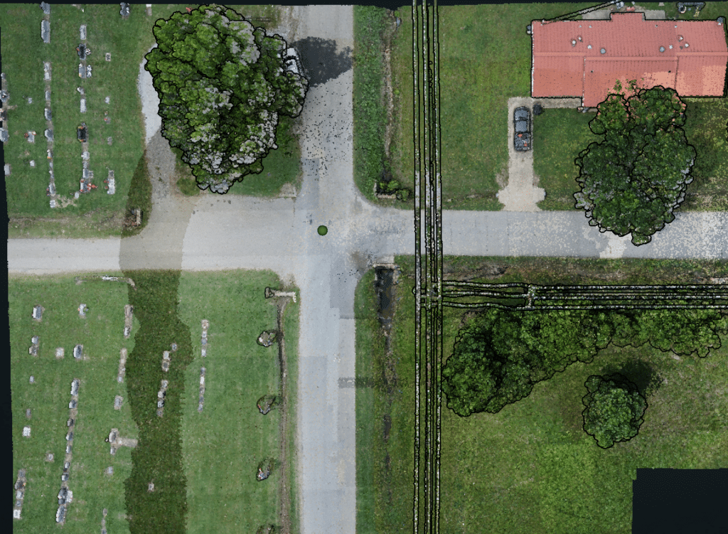
Once the raw LiDAR data is collected, it must be processed and analyzed to extract useful information. Processing software is used to filter, classify, and visualize the data, enabling users to create detailed 3D models and derive valuable insights.
Point Clouds and Digital Elevation Models
LiDAR data is often represented as point clouds, which are collections of individual data points representing the Earth’s surface. These point clouds, as described in this article on aerial LiDAR, can be further processed to create Digital Elevation Models (DEMs). DEMs provide continuous representations of the terrain and can be used for various applications, such as topographic mapping, flood modeling, and urban planning.
Understanding the four key components of a LiDAR system helps to appreciate the complexity and capabilities of this powerful technology. Each part plays a vital role in the data collection and analysis process, contributing to the accuracy and utility of LiDAR data across numerous industries and applications.
Ultraviolet (UV) Wavelengths
Ultraviolet wavelengths range from 10 to 400 nanometers (nm). Due to their high energy and shorter wavelengths, UV lasers can provide high-resolution measurements. However, they are more susceptible to atmospheric scattering and absorption, limiting their effective range.
Applications
- Material analysis: UV LiDAR systems can be used to study the composition of materials, such as mineral deposits or pollutants in the atmosphere.
- Fluorescence detection: Some materials emit fluorescence when exposed to UV light. UV LiDAR can be utilized to detect these emissions, providing valuable information for applications like remote sensing of vegetation or pollution monitoring.
Visible Wavelengths
Visible wavelengths range from 400 to 700 nm. While visible light LiDAR systems can provide high-resolution data and are relatively less affected by atmospheric scattering, they can be influenced by ambient light, making them less suitable for outdoor applications during daylight hours.
Applications
- Underwater mapping: Visible light LiDAR systems are effective in underwater environments where shorter wavelengths can penetrate the water more effectively than infrared wavelengths.
- Color imaging: Visible light LiDAR can capture color information, making it valuable for applications such as art conservation and cultural heritage documentation.
Infrared (IR) Wavelengths
Infrared wavelengths range from 700 nm to 1 millimeter (mm). Infrared LiDAR systems are the most common type used in aerial LiDAR applications due to their ability to penetrate atmospheric particles and vegetation, allowing for more accurate measurements of the Earth’s surface.
Applications
- Topographic mapping: Infrared LiDAR is widely used for creating detailed topographic maps, as it can accurately measure elevation and terrain features.
- Forest management: Infrared LiDAR can penetrate the forest canopy, providing valuable data on tree height, canopy density, and biomass for sustainable forest management practices.
- Urban planning: Infrared LiDAR is extensively used for urban planning and infrastructure development, as it can provide high-resolution data and accurate elevation measurements.
In summary, the choice of wavelength in a LiDAR system depends on the specific requirements of the application. Understanding the advantages and limitations of each wavelength range enables professionals to select the most appropriate LiDAR system for their needs, ensuring optimal performance and results.
Comparison to Other Technologies
When comparing LiDAR to other remote sensing and surveying technologies, it’s essential to consider the specific needs and requirements of the application. Here, we’ll examine how LiDAR compares to two common alternatives: photogrammetry and radar. For a more detailed comparison of LiDAR and other surveying methods, check out this article.
LiDAR vs. Photogrammetry
Photogrammetry is a technique that uses images captured from cameras to create 3D models and measurements of the environment. While both LiDAR and photogrammetry can generate accurate 3D models, they each have their strengths and limitations. To understand which technology offers better data accuracy, read this informative article.
- Accuracy: LiDAR generally provides higher accuracy and better resolution than photogrammetry, especially in areas with dense vegetation or complex terrain.
- Data Collection Speed: LiDAR can collect data more rapidly than photogrammetry, making it more suitable for large-scale projects and time-sensitive applications.
- Lighting Conditions: LiDAR is less affected by lighting conditions and can operate in low light or complete darkness, while photogrammetry relies on visible light and requires optimal lighting conditions for accurate results.
LiDAR vs. Radar
Radar is another remote sensing technology that uses radio waves to detect and measure objects. While both LiDAR and radar can provide accurate distance measurements, they have distinct differences in their operation and applications.
- Wavelength: LiDAR uses light waves, while radar uses radio waves. This difference in wavelength affects their ability to penetrate obstacles and atmospheric conditions. LiDAR is generally better suited for mapping the Earth’s surface and penetrating vegetation, while radar is more effective at penetrating clouds and precipitation.
- Resolution: LiDAR typically provides higher resolution data compared to radar, making it more suitable for applications requiring detailed 3D models and accurate elevation measurements.
- Size and Power Consumption: LiDAR systems are generally smaller and consume less power than radar systems, making them more suitable for applications like UAV-based surveys and mobile mapping.
In conclusion, LiDAR technology offers numerous benefits, making it a valuable tool across various industries and applications. By comparing LiDAR to other remote sensing technologies like photogrammetry and radar, professionals can determine the most suitable technology for their specific needs and requirements.
| Technology | Radar | Photogrammetry | LiDAR |
|---|---|---|---|
| Principle | Radio waves | 2D images | Laser pulses |
| Data type | Distance, speed, direction | 2D images, 3D models | 3D point clouds, intensity |
| Accuracy | Moderate | High | Very high |
| Resolution | Lower | High | Very high |
| Penetration | Can penetrate clouds, rain | Affected by clouds, shadows | Can penetrate vegetation |
| Light dependence | Independent of light | Requires good lighting | Independent of light |
| Data collection | Real-time, continuous | Discrete, individual images | Continuous, point cloud |
| Applications | Weather forecasting, aviation | Mapping, 3D modeling, planning | Surveying, forestry, civil engineering |
This table compares the key features of Radar, Photogrammetry, and LiDAR technologies, illustrating their differences in principles, data types, accuracy, resolution, penetration capabilities, light dependence, data collection methods, and applications.
To dive further into Photogrammetry, make sure to check out our Ultimate Guide to Photogrammetry and Orthomosaics.
The Three Basic Types of LiDAR
There are three primary types of LiDAR systems: airborne, terrestrial, and mobile. Each has its unique advantages and applications, making them suitable for different purposes.
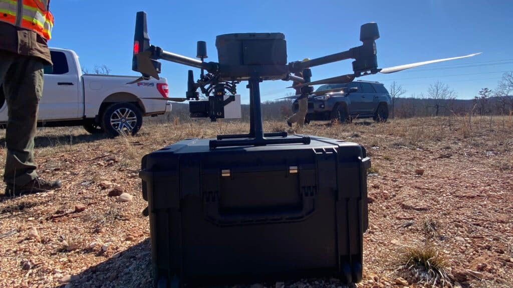
Airborne LiDAR
Airborne LiDAR systems are mounted on aircraft or drones and are used for large-scale mapping and surveying. They provide a bird’s-eye view of the Earth’s surface, allowing for the collection of vast amounts of data in a short period. This type of LiDAR is particularly useful for topographic mapping, environmental studies, and urban planning.
Fixed-Wing Aircraft and Helicopters
Airborne LiDAR systems can be mounted on various types of aircraft, including fixed-wing airplanes and helicopters. Fixed-wing aircraft are generally more efficient for large-scale mapping projects, as they can cover greater distances at higher speeds. Helicopters, on the other hand, offer increased maneuverability and can hover over specific areas, making them ideal for smaller, more targeted surveys.
Drones and UAVs
Drones and Unmanned Aerial Vehicles (UAVs) have become increasingly popular for LiDAR data collection due to their lower costs, ease of deployment, and ability to access hard-to-reach areas. Drones equipped with LiDAR sensors can quickly and accurately collect data in remote or hazardous locations, such as forests, mountains, and disaster zones.
Terrestrial LiDAR
Terrestrial LiDAR systems are ground-based and typically mounted on tripods. They are used for smaller-scale, high-resolution mapping and surveying, such as building inspections, construction sites, and archaeological sites. Terrestrial LiDAR provides more detailed data than airborne LiDAR but covers a smaller area.
Static Terrestrial LiDAR
Static terrestrial LiDAR systems are stationary during data collection, making them ideal for capturing detailed information about a specific location. These systems are commonly used for architectural and engineering applications, such as documenting historical buildings, monitoring infrastructure, and assessing structural damage.
Backpack and Handheld LiDAR
Backpack and handheld LiDAR systems offer increased mobility and flexibility, allowing surveyors to quickly and easily collect data in challenging environments, such as dense vegetation or urban environments. These portable systems can be carried by a single operator, making them an efficient option for smaller-scale projects.
Mobile LiDAR
Mobile LiDAR systems are mounted on moving vehicles, such as cars, boats, or trains, and are used for mapping and surveying while on the move. This type of LiDAR is particularly useful for transportation and infrastructure projects, as it can quickly collect data along roads, bridges, and railways.
Road and Rail Mobile LiDAR
Road and rail mobile LiDAR systems are specifically designed for transportation applications, such as mapping highways, tunnels, and railways. These systems can collect data at high speeds, allowing for efficient and accurate mapping of large areas in a short period.
Marine and Riverine LiDAR
Marine and riverine LiDAR systems are mounted on boats and other watercraft to collect data along coastlines, rivers, and other waterways. These systems are used for various applications, including coastal mapping, floodplain analysis, and monitoring erosion and sedimentation.
Bathymetric LiDAR
Bathymetric LiDAR systems are specialized for underwater mapping and surveying. They use a combination of laser technology and water-penetrating wavelengths to collect data on the seafloor, riverbeds, and other submerged surfaces. Bathymetric LiDAR is particularly useful for applications such as marine habitat mapping, coastal zone management, and underwater archaeology.
Future Trends in LiDAR Technology
As LiDAR technology continues to advance, we can expect to see several key trends shaping its future. These trends include:
- Miniaturization: As LiDAR sensors become smaller and more lightweight, their integration into compact devices, such as smartphones and wearables, will become more prevalent. This will lead to an expansion of LiDAR applications in everyday life.
- Improved Accuracy: Advances in LiDAR technology will result in even higher resolution data and improved accuracy, making it increasingly valuable for various industries and applications.
- Real-time Data Processing: The ability to process LiDAR data in real-time will lead to new applications and capabilities, such as real-time monitoring of infrastructure or traffic flow management.
- Integration with Other Technologies: Combining LiDAR with other data sources, such as imagery or multispectral data, will provide richer and more comprehensive datasets for analysis and decision-making.
- Automation and Machine Learning: As LiDAR data becomes more accessible and easier to process, machine learning algorithms will be increasingly used to analyze and interpret the data, leading to improved efficiency and new insights.
In conclusion, LiDAR technology continues to revolutionize various industries and sectors, offering numerous applications and benefits. As the technology advances and becomes more widely adopted, we can expect even more innovative uses for LiDAR in the future.
LiDAR Accuracy and Its Importance
The accuracy of LiDAR data is a critical aspect of its value, as it directly impacts the quality and reliability of the resulting 3D models and measurements. In this section, we will explore the factors that influence LiDAR accuracy, typical accuracies achieved by different LiDAR systems, and how accuracy can be improved.
Factors Affecting LiDAR Accuracy
Several factors can influence the accuracy of LiDAR data, including:
System Specifications: The technical specifications of the LiDAR sensor, such as the range, beam divergence, and pulse rate, can impact the data’s accuracy. Higher-quality sensors with better specifications typically produce more accurate data.
Platform Stability: The stability of the platform (aircraft, UAV, vehicle, etc.) carrying the LiDAR system can affect the accuracy of the measurements. Unstable platforms can introduce errors in the data.
Atmospheric Conditions: Weather conditions, such as rain, fog, or dust, can influence the accuracy of LiDAR data by scattering or absorbing the emitted laser pulses, leading to measurement errors.
Terrain and Vegetation: Complex terrain and dense vegetation can impact LiDAR accuracy by causing multiple reflections or signal attenuation, making it challenging to determine the precise location of the ground surface.
Data Processing: The quality of the data processing algorithms used to convert raw LiDAR data into meaningful information can significantly influence the accuracy of the final output.
Typical LiDAR Accuracies
Different LiDAR systems can achieve varying levels of accuracy, depending on the factors mentioned above. Here are some general ranges of accuracies for common LiDAR platforms:
Aerial LiDAR: Aerial LiDAR systems, mounted on airplanes or helicopters, typically achieve vertical accuracies of 10 to 25 cm and horizontal accuracies of 30 to 50 cm.
Terrestrial LiDAR: Terrestrial LiDAR systems, which are ground-based and often used for surveying and construction applications, can achieve vertical and horizontal accuracies of 1 to 5 cm.
Mobile LiDAR: Mobile LiDAR systems, mounted on vehicles, can achieve vertical and horizontal accuracies of 2 to 10 cm, depending on factors like the sensor quality, vehicle speed, and GPS accuracy.
UAV LiDAR: LiDAR systems mounted on Unmanned Aerial Vehicles (UAVs) can achieve vertical accuracies of 5 to 15 cm and horizontal accuracies of 10 to 30 cm.
Improving LiDAR Accuracy
There are several ways to improve the accuracy of LiDAR data, including:
Using High-Quality Sensors: Investing in LiDAR sensors with better specifications can lead to more accurate data.
Stabilizing the Platform: Ensuring a stable platform can minimize errors introduced by platform movement.
Optimizing Data Collection: Collecting data under optimal atmospheric conditions and adjusting flight altitude or scan angle can help minimize errors.
Data Processing and Filtering: Employing advanced data processing algorithms and filtering techniques can help improve the accuracy of the final output.
In conclusion, the accuracy of LiDAR data is influenced by various factors, and different LiDAR systems can achieve different levels of accuracy. Understanding these factors and implementing strategies to improve accuracy can ensure that LiDAR data meets the requirements of specific applications and provides reliable and high-quality information. To learn more about LiDAR accuracy and how to improve it, check out this article.

Exploring the Multifaceted Applications of Aerial LiDAR
Aerial LiDAR, recognized as one of the most precise and accurate remote sensing technologies, has vast potential across diverse domains due to its laser scanning technique for data collection. This powerful tool enables the creation of detailed 3D models of scanned terrains and objects, and its extensive capabilities for analyzing and visualizing the world around us are worth investigating. In this section, we explore various fields, such as transportation engineering, forestry, archaeology, urban planning, and geology, to uncover the numerous applications of Aerial LiDAR.
Aerial LiDAR’s Wide-ranging Uses Across Industries
Land Surveying and Mapping
Aerial LiDAR provides highly accurate topographic data essential for creating detailed maps, planning infrastructure, and managing resources. It allows for efficient and precise data collection in large areas, significantly reducing the time and effort required for traditional surveying methods. Explore the hidden costs of low-quality LiDAR data and learn why you shouldn’t sacrifice accuracy for savings.
Forestry
LiDAR data enables the assessment of forest biomass, tree height, and canopy density, which can inform sustainable forest management practices. This information is vital for monitoring forest health, evaluating conservation efforts, and estimating carbon sequestration potential. Discover the power of drone LiDAR in forestry management.
Floodplain Mapping
By generating detailed elevation models, LiDAR can be used to predict flood-prone areas and create more accurate floodplain maps. These maps help inform land use planning, flood mitigation strategies, and emergency response efforts. Learn how LiDAR is applied in hydrology.
Archaeology
Aerial LiDAR can reveal hidden archaeological features, such as ancient structures and settlements, buried beneath dense vegetation or soil. This non-invasive technique has led to significant discoveries and has transformed the way archaeologists investigate and map cultural heritage sites. Learn about how LiDAR is impacting the field of Archaeology.
Urban Planning
With high-resolution 3D data, city planners can analyze existing infrastructure, identify potential development sites, and assess the impact of proposed projects. Aerial LiDAR helps ensure that urban development is carried out in a sustainable, efficient, and well-informed manner. Discover how LiDAR is changing the face of urban development.
Transportation
Aerial LiDAR is used to survey and design transportation infrastructure, including roads, bridges, and railways, by providing accurate terrain data. This information assists engineers in optimizing routes, identifying potential hazards, and minimizing environmental impacts. Learn about LiDAR applications in civil engineering.
Energy
In the energy sector, LiDAR data plays a crucial role in site selection, assessment, and monitoring for various types of projects, including renewable energy sources and traditional oil and gas operations. By providing detailed information on terrain, wind patterns, and solar radiation, LiDAR helps maximize the efficiency and sustainability of energy projects. Explore LiDAR’s impact on power and distribution, and learn how it revolutionizes oil and gas operations from exploration to refining. For another drone based sensor with tremendous value to the Oil and Gas industry, it is also recommended to check out an overview of Optical Gas Inspections.
Hydrology
LiDAR technology is highly beneficial for various hydrological applications, such as watershed analysis, river channel mapping, and flood risk assessment. With its high-resolution elevation data, LiDAR helps in understanding the water flow patterns and potential water storage sites, contributing to effective water resource management. Discover the potential of LiDAR in hydrology applications.
Infrastructure Maintenance
Aerial LiDAR, especially when deployed using drones, has proven to be a cost-effective solution for inspecting and maintaining critical infrastructure elements. With its accurate data collection capabilities, LiDAR helps identify potential vulnerabilities and maintenance needs, allowing for more efficient asset management. Learn how drone LiDAR is reducing costs in infrastructure maintenance.
Geological Studies
LiDAR technology has been invaluable in geological studies, such as assessing earthquake hazards and studying glaciology and ice sheets. By providing accurate and detailed elevation data, LiDAR enables researchers to identify fault lines, monitor glacier movements, and study ice sheet dynamics, thus enhancing our understanding of Earth’s geology. Explore the use of LiDAR in earthquake hazard assessment and its applications in glaciology and ice sheet studies.
Construction
LiDAR has become an indispensable tool for construction professionals, as it enables the creation of accurate 3D models of construction sites and surrounding areas. By providing valuable data on topography, existing structures, and utilities, LiDAR helps optimize construction processes, reduce costs, and improve safety. Learn how drone LiDAR is a game-changer for construction professionals.
Real Estate
Aerial LiDAR is revolutionizing the real estate industry by providing highly accurate and up-to-date information on property boundaries, terrain features, and nearby amenities. This data can be used to create detailed property listings, assess land values, and inform development decisions, ultimately improving the efficiency and transparency of the real estate market. Discover how drone LiDAR is changing the game in real estate.
Integration with GIS
LiDAR data can be seamlessly integrated with Geographic Information Systems (GIS) to create powerful tools for spatial analysis, decision-making, and visualization. By combining LiDAR’s accurate elevation data with other geospatial data layers, GIS professionals can generate detailed maps, perform advanced spatial analyses, and develop innovative solutions for various industries. Learn more about the integration of LiDAR and GIS.
Land Development
Aerial LiDAR is transforming the field of land development by providing detailed and accurate information on topography, vegetation, and existing infrastructure. This data enables developers, engineers, and planners to make informed decisions about site selection, design, and project feasibility, ultimately improving the efficiency and sustainability of land development projects. Discover the potential of LiDAR in land development and learn about the opportunities and challenges.
In conclusion, Aerial LiDAR has a wide range of applications across numerous industries, providing valuable insights and data for better decision-making and resource management. By continually advancing and evolving, LiDAR technology promises to unlock even more possibilities for enhancing our understanding of the world and improving the way we live and work.

Exploring the Advantages of Aerial LiDAR Technology
Aerial LiDAR technology offers several significant benefits over conventional surveying and mapping methods. In this section, we will examine the key advantages of utilizing aerial LiDAR for data collection and analysis.
Speed and Efficiency: A Cornerstone of LiDAR Surveys
LiDAR surveys are renowned for their capacity to cover vast areas in a relatively brief period, substantially reducing the time and resources necessary for data collection. This efficiency stems from the use of airborne platforms, such as helicopters and fixed-wing aircraft, which facilitate swift data acquisition over large distances. Consequently, projects can be completed more rapidly, with reduced logistical challenges compared to traditional ground-based surveying techniques.
Some factors contributing to LiDAR surveys’ speed and efficiency include:
- High pulse rate: Contemporary LiDAR systems can emit hundreds of thousands of laser pulses per second, enabling them to gather a considerable amount of data quickly.
- Simultaneous data acquisition: LiDAR systems can obtain elevation, intensity, and georeferenced data concurrently, streamlining the data collection process and minimizing the necessity for multiple survey passes.
- Automated data processing: Cutting-edge software tools can swiftly process LiDAR data, converting raw point clouds into valuable information for various applications, such as digital elevation models and 3D visualizations.
The speed and efficiency of LiDAR systems are especially beneficial for applications in the following sectors:
- Emergency response and disaster management: LiDAR technology can be deployed promptly to collect data following natural disasters, like floods, landslides, or earthquakes, aiding in rapid assessment and response initiatives.
- Time-sensitive infrastructure projects: The fast data collection capabilities of aerial LiDAR can accelerate the planning and design stages of infrastructure projects, such as road construction, bridge design, or utility network upgrades.
- Large-scale environmental monitoring: LiDAR technology can be utilized to rapidly gather data for environmental monitoring and management applications, like tracking deforestation, evaluating habitat changes, or monitoring coastal erosion.
By offering swift and efficient data collection solutions, LiDAR technology has become an essential tool for various industries and applications that demand rapid, precise, and detailed data for decision-making and project implementation.
The Importance of High Accuracy in Aerial LiDAR Technology
Aerial LiDAR is celebrated for its ability to attain centimeter-level accuracy, supplying precise and dependable data for a wide variety of applications. This exceptional degree of accuracy is vital for numerous industries and fields, where even minor discrepancies can result in significant consequences.
Some factors contributing to LiDAR surveys’ high accuracy include:
- Precise distance measurements: LiDAR technology employs the time-of-flight principle to compute distances with remarkable precision. The system gauges the time it takes for laser pulses to travel to the ground and back, yielding highly accurate distance measurements.
- Advanced GPS and IMU integration: LiDAR systems generally integrate with GPS receivers and Inertial Measurement Units (IMUs) to record the aircraft’s position and orientation during the survey. This information is crucial for accurately georeferencing the gathered data and ensuring that the resulting 3D models are precise and dependable.
- High point density: Contemporary LiDAR systems can produce extremely dense point clouds, with millions of points per square kilometer. This high point density enables the creation of detailed and accurate representations of the surveyed area.
The high accuracy of aerial LiDAR is essential for various applications, such as:
- Infrastructure planning: Accurate topographic data is crucial for designing and constructing roads, bridges, and other infrastructure projects. LiDAR data assists engineers in identifying potential challenges, optimizing designs, and ensuring the stability and safety of structures.
- Environmental monitoring: Precise LiDAR data is vital for evaluating changes in ecosystems, monitoring erosion, and measuring the impacts of natural disasters. This information aids in the development of effective strategies for environmental protection and restoration.
- Archaeological investigations: The exceptional accuracy of aerial LiDAR allows archaeologists to uncover hidden features, such as ancient structures and settlements, and gain detailed insights into past civilizations and their landscapes.
By delivering centimeter-level accuracy, aerial LiDAR technology has become an indispensable tool for industries and applications that demand precise and reliable data.
Unmatched Versatility of LiDAR Systems
LiDAR systems are recognized for their extraordinary versatility, facilitating data collection in challenging environments where traditional methods might struggle. The ability to penetrate dense vegetation and other obstacles makes LiDAR excel in projects that necessitate access to remote or hard-to-reach locations.
Some factors contributing to the versatility of LiDAR systems include:
- Active sensing technology: Unlike passive remote sensing techniques, such as photogrammetry, LiDAR systems emit their own light source. This active sensing capability enables LiDAR to function effectively in various lighting conditions, including low light or complete darkness.
- Canopy penetration: LiDAR laser pulses can penetrate dense vegetation, reaching the ground beneath the canopy. This feature allows the collection of accurate topographic data in forested areas, where traditional ground-based surveying methods might be hindered by thick foliage.
- Wide range of platforms: LiDAR systems can be mounted on diverse airborne platforms, such as helicopters, fixed-wing aircraft, and unmanned aerial vehicles (UAVs). This adaptability enables LiDAR to be employed in various environments, from vast open landscapes to rugged and remote terrain.
The versatility of LiDAR systems makes them a top choice for a broad range of applications, including:
- Forestry: LiDAR’s capacity to penetrate dense canopies enables accurate measurements of tree height, canopy density, and forest biomass, promoting sustainable forest management practices.
- Archaeology: LiDAR can expose hidden archaeological features beneath dense vegetation or soil, facilitating the discovery of ancient structures and settlements that might otherwise remain hidden.
- Coastal and riverine studies: LiDAR can be utilized to map coastal and riverine environments, supplying valuable information on erosion patterns, sediment transport, and habitat characteristics in areas that may be challenging to access with traditional methods.
By offering unmatched versatility, LiDAR technology has become an invaluable asset for industries and applications that require data collection in diverse and challenging environments.
Enhanced Safety with Aerial LiDAR Technology
Aerial LiDAR, as a remote sensing technology, significantly improves the safety of data collection processes by eliminating the need for ground-based surveyors to access dangerous or hard-to-reach areas. This approach not only minimizes the risk of accidents and injuries but also ensures the well-being of personnel involved in the data collection process.
Some factors contributing to the enhanced safety of LiDAR systems include:
- Reduced physical exposure: Aerial LiDAR surveys are conducted from the air, meaning surveyors don’t have to traverse challenging terrain or access perilous locations on the ground. This reduced physical exposure helps prevent accidents and injuries associated with traditional ground-based surveying methods.
- Remote data acquisition: LiDAR systems can gather data from a distance, enabling surveyors to obtain information from hazardous areas, such as landslides, unstable slopes, or contaminated sites, without jeopardizing their safety.
- Minimal disruption: Aerial LiDAR surveys cause minimal disruption to the environment, lowering the likelihood of accidents or injuries resulting from disturbances to wildlife, vegetation, or unstable ground conditions.
The enhanced safety of LiDAR systems is particularly valuable for applications in the following areas:
- Disaster response and management: LiDAR can be employed to assess the impact of natural disasters, such as floods, earthquakes, or landslides, without exposing surveyors to dangerous conditions on the ground.
- Mining and quarrying: Aerial LiDAR surveys can provide accurate topographic data for mines and quarries, reducing the need for surveyors to access hazardous locations, such as steep slopes or unstable terrain.
- Infrastructure inspection: LiDAR technology can be utilized to inspect bridges, dams, and other infrastructure assets from a safe distance, minimizing the risk of accidents and injuries associated with traditional inspection methods.
By prioritizing safety, aerial LiDAR technology has become an indispensable tool for industries and applications that require data collection in hazardous or challenging environments, protecting both personnel and the environment in the process.

Understanding the Limitations and Disadvantages of Aerial LiDAR Technology
Aerial LiDAR has established itself as an essential tool for various applications, from mapping and surveying to environmental monitoring. However, as with any technology, it has its limitations and disadvantages. In this section, we will discuss these challenges and their impact on specific applications, and explore when alternative methods may be more appropriate.
Key Limitations and Disadvantages of Aerial LiDAR
High cost of equipment and data processing: Acquiring LiDAR equipment and the required software for data processing can be expensive, which may discourage smaller organizations or projects with limited budgets from adopting this technology.
Limited performance in certain environments: Aerial LiDAR systems can have difficulty penetrating highly reflective surfaces like water or snow, leading to less accurate data in these specific environments.
Sensitivity to atmospheric conditions: While LiDAR systems are less affected by weather and lighting conditions than other remote sensing technologies, extreme atmospheric conditions such as heavy rain or fog can still impact the quality of the collected data.
Data complexity and storage requirements: LiDAR generates vast amounts of data that necessitate significant storage space and specialized software for processing and analysis. This can be resource-intensive for some organizations.
When Aerial LiDAR May Not Be the Best Choice
Certain applications or situations may be more challenging for Aerial LiDAR due to its limitations and disadvantages:
Small-scale projects or organizations with limited budgets: The cost of acquiring and maintaining LiDAR equipment and software may be prohibitive for smaller organizations or projects with constrained budgets. Traditional surveying methods or alternative remote sensing technologies may be more attractive in these cases.
Surveys in water or snow-covered environments: In cases where the terrain is covered by water or snow, alternative remote sensing technologies such as bathymetric LiDAR or radar might provide more accurate data collection.
Areas with extreme weather conditions: Regions with frequent heavy rain, fog, or other extreme atmospheric conditions may compromise LiDAR data quality. Alternative or supplementary data collection methods should be considered in these situations.
Organizations with limited data processing resources: Organizations that lack the necessary computing resources or expertise to handle and process large volumes of LiDAR data may find alternative remote sensing technologies or traditional surveying methods more appropriate.
Aerial LiDAR is a powerful and versatile remote sensing technology that has proven valuable in various applications. However, it is crucial to consider its limitations and disadvantages when selecting the most suitable data collection method for specific projects and applications. By doing so, organizations can ensure that they make informed decisions that lead to the best possible outcomes for their projects.
Data Privacy and Ethical Concerns
As with any technology that collects data, Aerial LiDAR raises concerns regarding data privacy and ethical usage. It is crucial for organizations and individuals employing LiDAR technology to adhere to responsible data collection and usage practices to mitigate potential risks and ensure ethical conduct. In this section, we will discuss some of the key data privacy and ethical concerns associated with Aerial LiDAR and provide guidance on responsible data collection. The Ethics of Drone LiDAR: A Guide to Responsible Data Collection
Privacy Concerns
Aerial LiDAR systems can capture high-resolution 3D data that, in some cases, might reveal sensitive information about individuals, properties, or businesses. This may lead to privacy concerns and potential legal issues if not handled appropriately. To address privacy concerns, it is essential to:
- Obtain necessary permits and permissions before collecting LiDAR data, particularly when flying over private property or restricted areas.
- Implement data anonymization techniques to protect the privacy of individuals and avoid disclosing personally identifiable information (PII).
- Establish clear data usage policies and adhere to applicable data protection regulations, such as the General Data Protection Regulation (GDPR) in Europe.
Ethical Data Collection and Usage
To ensure the ethical collection and usage of Aerial LiDAR data, organizations and individuals should consider the following best practices:
- Develop and implement ethical guidelines and protocols for data collection, storage, and analysis.
- Train staff members and stakeholders on responsible data collection, handling, and privacy practices.
- Be transparent about the purpose of the data collection and share the intended benefits and outcomes with relevant stakeholders.
- Collaborate with local communities and authorities, addressing any concerns and incorporating their input into the data collection process.
By adhering to responsible data collection and ethical practices, organizations and individuals can harness the full potential of Aerial LiDAR technology while mitigating risks and ensuring privacy and ethical considerations are addressed.
Learning and Mastering LiDAR Technology
LiDAR technology has immense potential across various industries, and mastering it can be a rewarding and valuable skill. In this section, we will address common questions about learning LiDAR technology, including difficulty, where to learn, and how to become a LiDAR expert.
Is it Hard to Learn LiDAR?
The difficulty of learning LiDAR technology varies depending on your background and experience. If you have a solid foundation in fields such as remote sensing, geography, or engineering, you may find it easier to grasp LiDAR concepts. However, even without prior experience, LiDAR technology can be learned with dedication and the right resources.
Where Can I Learn About LiDAR?
There are numerous resources available to learn about LiDAR technology:
- Online Courses and Tutorials: Websites such as Coursera, Udemy, and YouTube offer various courses and tutorials on LiDAR technology, ranging from beginner to advanced levels.
- Workshops and Seminars: Many professional organizations and academic institutions host workshops, seminars, and conferences focused on LiDAR technology and its applications.
- Books and Publications: Numerous books and scientific publications cover LiDAR principles, techniques, and applications, providing valuable insights for learners.
- Networking and Community: Joining LiDAR-related forums, groups, and social media communities can help you connect with other professionals, learn from their experiences, and stay up-to-date with the latest trends and developments.
How Do I Become a LiDAR Expert?
Becoming a LiDAR expert requires a combination of education, practical experience, and continuous learning:
- Education: Acquiring a strong foundation in relevant fields such as geography, remote sensing, computer science, or engineering can help you better understand LiDAR technology.
- Hands-on Experience: Gaining practical experience with LiDAR systems, data processing, and analysis is essential for becoming an expert. This can be achieved through internships, projects, or working with organizations that use LiDAR technology.
- Certifications: Obtaining certifications in LiDAR technology or related fields can help you demonstrate your expertise and stand out in the job market.
- Continuous Learning: Stay up-to-date with the latest advancements, trends, and best practices in LiDAR technology by attending conferences, workshops, and following industry publications.
What Programming Language is Best for LiDAR?
While there is no single “best” programming language for LiDAR, some popular languages used in LiDAR data processing and analysis include Python, C++, and Java. Python, in particular, is widely used due to its readability, extensive libraries, and strong community support.
LiDAR in Space Exploration and Elon Musk’s Views
LiDAR has also made its mark in space exploration, with NASA using it for various purposes. However, Elon Musk, the CEO of Tesla and SpaceX, has expressed his skepticism about LiDAR technology. In this section, we will discuss LiDAR usage in space, Elon Musk’s opinions, and the reasons behind his views.
What LiDAR Does NASA Use?
NASA has been using LiDAR technology for multiple applications in space exploration. Some notable examples include:
- ICESat and ICESat-2: These satellite missions use LiDAR to measure ice sheet elevation, sea ice thickness, and vegetation canopy height to study Earth’s changing climate.
- GEDI (Global Ecosystem Dynamics Investigation): This LiDAR instrument aboard the International Space Station provides detailed information on the structure of Earth’s forests to study biodiversity and carbon cycling.
- Mars Rover: NASA’s Mars rovers, such as Curiosity and Perseverance, have used LiDAR for navigation, terrain mapping, and obstacle detection during their exploration of the Martian surface.
Why is Elon Musk Against LiDAR?
Elon Musk has been vocal about his skepticism towards LiDAR technology for autonomous vehicles. He believes that cameras, combined with advanced computer vision and artificial intelligence, can provide the necessary data for self-driving cars without the need for LiDAR.
What is More Accurate Than LiDAR?
While LiDAR offers high accuracy and precision, Elon Musk argues that cameras can provide even better accuracy by replicating the human vision system. With the right algorithms and processing power, cameras can detect objects, estimate distances, and recognize patterns in real-time, potentially achieving superior performance than LiDAR in some situations.
Understanding the Costs of LiDAR Systems
The cost of LiDAR systems can vary significantly depending on the type of sensor, its specifications, and the intended application. In this section, we’ll discuss the factors that influence the cost of LiDAR systems and provide some general price ranges for different types of sensors. A Guide to Choosing the Perfect Drone LiDAR System for Your Needs
Factors Influencing LiDAR Costs
Several factors can influence the cost of a LiDAR system, including:
Sensor Type
The type of LiDAR sensor (mechanical, solid-state, or flash) can greatly affect the cost. Mechanical LiDAR systems, which use spinning mirrors to direct the laser pulses, are typically more expensive due to their complexity and moving parts. Solid-state and flash LiDAR systems, which do not have moving parts, are generally more affordable.
Resolution and Range
Higher-resolution LiDAR sensors with longer detection ranges tend to be more expensive due to the increased complexity and higher-quality components required.
Beam Divergence
LiDAR systems with narrow beam divergence typically cost more because they provide more precise measurements and require more advanced components.
Wavelength
The choice of laser wavelength (e.g., 905 nm or 1550 nm) can also influence the cost of a LiDAR system. Longer-wavelength LiDAR systems are typically more expensive due to the need for specialized laser components and detectors.
Manufacturing Scale
As with any technology, economies of scale can drive down the cost of LiDAR systems as production volumes increase and manufacturing processes become more efficient.
By considering these factors, you can make an informed decision when choosing the right LiDAR system for your specific needs, ensuring that you get the best value for your investment.
LiDAR Price Ranges
While it’s difficult to provide exact pricing for LiDAR systems due to the wide variety of specifications and applications, the following price ranges can serve as a general guide:
Low-cost LiDAR sensors: These sensors are typically priced between $500 and $5,000 and are often used in applications such as drones, robotics, and lower-end automotive systems. Examples include solid-state LiDAR sensors and low-resolution, short-range mechanical LiDAR systems.
Mid-range LiDAR sensors: Mid-range sensors generally cost between $5,000 and $30,000 and are used in applications requiring higher resolution and longer detection ranges, such as autonomous vehicles, advanced robotics, and industrial automation. Examples include high-resolution solid-state LiDAR systems and mid-range mechanical LiDAR sensors.
High-end LiDAR sensors: These sensors can cost upwards of $30,000 and are typically used in high-precision applications like aerial mapping, surveying, and advanced autonomous vehicle systems. Examples include high-resolution, long-range mechanical LiDAR systems and specialized solid-state sensors.
It’s important to note that these price ranges are approximate and can vary depending on the specific LiDAR system and its intended application. As LiDAR technology continues to advance and adoption increases, it’s likely that costs will continue to decrease, making LiDAR more accessible and affordable for a wider range of applications.
Types of Products Created with LiDAR Data
LiDAR technology has a wide range of applications, and the data collected can be used to create various products that serve different industries and purposes. In this section, we’ll explore some of the key products that can be generated using LiDAR data.
Digital Elevation Models (DEMs)
A Digital Elevation Model (DEM) is a representation of the terrain’s surface, providing information about elevation and slope. DEMs can be used for applications such as floodplain mapping, infrastructure planning, and environmental assessments. They are essential for understanding the contours and features of a landscape.
Digital Surface Models (DSMs)
Digital Surface Models (DSMs) are similar to DEMs but include natural and man-made features like vegetation and buildings. They provide a more detailed representation of the earth’s surface, making them useful for urban planning, forestry, and telecommunications.
Digital Terrain Models (DTMs)
Digital Terrain Models (DTMs) are derived from DEMs by removing surface features such as vegetation and buildings. DTMs provide a bare-earth representation of the terrain and are used in applications like hydrological modeling and landscape analysis.
3D Models and Point Clouds
LiDAR data can be used to create 3D models and point clouds, which are collections of data points representing the surface of an object or landscape. These 3D models can be used in architecture, engineering, and construction projects for visualization and planning purposes. Point clouds can also be used for volumetric calculations, such as determining stockpile volumes or measuring cut and fill in construction projects.
Contours and Breaklines
Contours are lines that connect points of equal elevation on a map, while breaklines represent significant changes in elevation or slope. LiDAR data can be used to generate accurate contour maps and breaklines, which are essential for topographic mapping, land development, and civil engineering projects.
LiDAR Planimetrics
LiDAR Planimetrics can help save time and money on mapping projects by providing accurate horizontal measurements and positions of features such as buildings, roads, and other infrastructure. This information is crucial for creating high-quality base maps and supporting land development, urban planning, and transportation projects.
Vegetation Analysis
LiDAR can provide valuable insights into vegetation structure, density, and height. This information can be used for various purposes, including forest management, habitat assessment, and conservation efforts. One specific application of LiDAR in vegetation analysis is biomass estimation, which helps in understanding the distribution and volume of biomass in a forest ecosystem, informing sustainable management practices and carbon sequestration studies.
Asset and Infrastructure Inspection
Using LiDAR data, asset and infrastructure inspections can be conducted more efficiently and accurately. This includes monitoring the condition of powerlines, pipelines, and transportation infrastructure, such as roads and bridges. Drone LiDAR, in particular, has been revolutionizing infrastructure inspection by offering a safer and more cost-effective approach to evaluating and maintaining these critical assets. For example, power line vegetation management can be significantly improved using LiDAR data to identify potential risks, such as overgrown trees or vegetation encroaching on power lines, and plan maintenance activities accordingly.
In summary, LiDAR data can be applied across a wide range of industries and use cases, offering improved efficiency, accuracy, and safety in various projects. The versatility of LiDAR technology continues to drive its adoption and innovation, making it an essential tool for modern decision-making and planning.
Getting Started with Aerial LiDAR
If you’re interested in using aerial LiDAR for data collection and analysis, there are a few key things to keep in mind. In this section, we’ll provide some practical advice for getting started with aerial LiDAR.
Choosing the Right LiDAR System and Sensor
Selecting the appropriate LiDAR system and sensor is crucial to ensuring the success of your project. The choice of system and sensor should be based on the specific requirements of your application, considering factors such as project scale, budget, and data accuracy needs. Here are some key aspects to consider when selecting the right LiDAR system and sensor:
- Project objectives and requirements: Clearly define the goals and data requirements of your project. This will help you determine the level of accuracy, resolution, and coverage needed, which in turn will inform your choice of LiDAR system and sensor.
- Budget considerations: Evaluate your budget constraints and the costs associated with different LiDAR systems and sensors. While higher-end systems may offer better performance, they may also be more expensive, so consider the trade-offs between cost and performance when making your decision.
- Platform compatibility: Ensure that the chosen LiDAR system and sensor are compatible with your intended platform, such as a fixed-wing aircraft, helicopter, or UAV. Platform compatibility is crucial for achieving optimal data collection and minimizing logistical challenges during the survey.
- Sensor specifications: Examine the specifications of different LiDAR sensors, such as their range, pulse rate, and accuracy, to identify the most suitable option for your project. Pay close attention to factors like maximum and minimum range, beam divergence, and scan angle, as these can significantly impact the quality of the collected data.
When evaluating LiDAR systems and sensors for specific applications, consider the following scenarios:
- Large-scale surveying projects: For extensive surveying projects, such as mapping an entire city or monitoring a vast forest, choose a LiDAR system with a long-range sensor and high pulse rate to ensure efficient data collection and wide coverage.
- High-accuracy applications: For projects that demand high accuracy, such as infrastructure planning or archaeological investigations, opt for a LiDAR system with a high-precision sensor that can achieve centimeter-level accuracy.
- Projects with limited budgets: If budget constraints are a significant concern, consider more affordable LiDAR systems or sensors that still offer adequate performance for your specific application. Alternatively, explore the possibility of renting LiDAR equipment to reduce upfront costs.
- Challenging environments: For projects in environments with dense vegetation or difficult-to-access areas, select a LiDAR system with a sensor capable of penetrating obstacles and providing accurate data in such conditions.
By carefully considering your project’s objectives, requirements, and constraints, you can make an informed decision when selecting the most suitable LiDAR system and sensor for your application. This will help ensure the successful execution of your project and the optimal use of the collected data.
Market Leaders and Notable Players in LiDAR Technology
The LiDAR industry is rapidly growing, with several companies leading the charge in developing and providing innovative solutions for various applications. In this section, we’ll discuss some of the market leaders and notable players in the world of LiDAR technology.
Velodyne LiDAR
Velodyne is one of the pioneers in the LiDAR industry and has been a dominant player since the early 2000s. They are known for their spinning multi-beam LiDAR sensors, which have found applications in autonomous vehicles, robotics, mapping, and other areas. Velodyne’s product portfolio includes the popular HDL-64E, Puck, and VLP-16 sensors, catering to different market segments and requirements.
Luminar Technologies
Luminar Technologies is another key player in the LiDAR industry, focusing primarily on developing LiDAR systems for autonomous vehicles. Their high-performance solid-state LiDAR sensors are designed for long-range, high-resolution, and safe operation in various environments. Luminar’s sensors have attracted attention from major automakers, making them a promising company in the LiDAR market.
Quanergy Systems
Quanergy Systems is a leading provider of solid-state LiDAR sensors that offer compact size, lower cost, and increased reliability compared to traditional spinning LiDAR systems. Their S3 sensor is a popular choice for various applications, including automotive, robotics, and security. Quanergy is known for its innovations in LiDAR technology and has a strong patent portfolio.
Leica Geosystems
Leica Geosystems is a well-established company in the geospatial industry and has been offering LiDAR solutions for aerial mapping and surveying for many years. Their airborne LiDAR systems, such as the Leica ALS series, are known for their high accuracy, precision, and ability to capture dense point clouds for detailed terrain models and feature extraction.
Innoviz Technologies
Innoviz Technologies is an Israeli start-up specializing in solid-state LiDAR systems for autonomous vehicles and other applications. Their InnovizOne and InnovizPro sensors offer high-resolution, long-range detection capabilities, and have attracted partnerships with major automotive manufacturers like BMW.
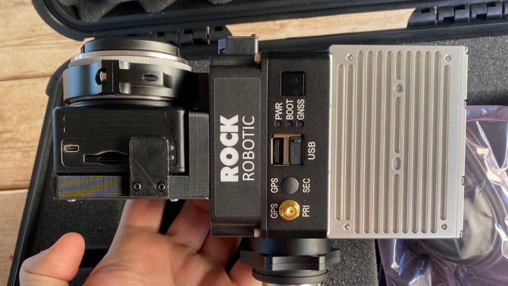
Rock Robotic
Rock Robotic is an innovative company offering advanced LiDAR solutions, such as the Rock Robotic R2A and the Rock R3Pro. These products are revolutionizing the drone LiDAR hardware market by providing cutting-edge technology and game-changing performance. Rock Robotic’s LiDAR systems have a wide range of applications, including mapping, inspection, and monitoring.
These are just a few of the many companies actively involved in the LiDAR industry, each contributing to the technology’s advancement and adoption across various sectors. As the demand for LiDAR continues to grow, we can expect more players to enter the market and drive innovation even further.
Preparing for a LiDAR Mapping Project
Before embarking on a LiDAR mapping project, it is essential to take the necessary steps to ensure a smooth and successful process. Proper preparation can help minimize challenges and maximize the quality of the data collected. Here are some key aspects to consider when preparing for a LiDAR mapping project:
Define project objectives and requirements: Establish the goals and specific data requirements of your project. This will help guide the selection of the appropriate LiDAR system and sensor, as well as inform the planning and execution of the survey.
Select the right LiDAR system and sensor: Based on your project objectives and requirements, choose a suitable LiDAR system and sensor that meet your needs in terms of accuracy, coverage, and budget.
Determine the optimal flight parameters: Plan the flight parameters, such as altitude, speed, and flight line spacing, to achieve the desired data quality and resolution. These parameters will depend on factors like the terrain, vegetation, and the chosen LiDAR system’s capabilities.
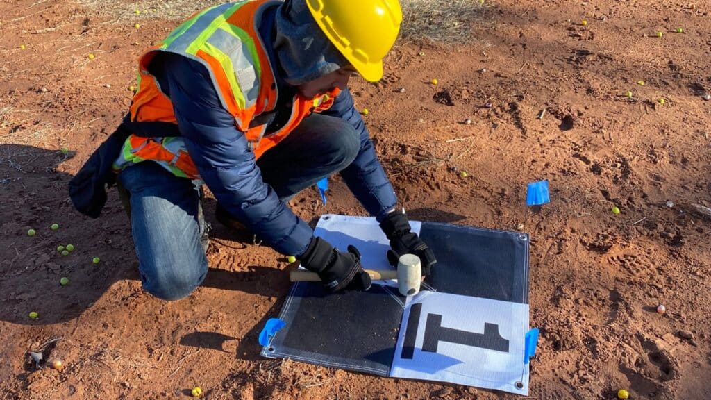
Perform a thorough site assessment: Conduct a site assessment to identify potential hazards, obstacles, and logistical challenges that may affect the LiDAR survey. This assessment will help you plan for contingencies and mitigate risks during the data collection process.
Obtain necessary permits and approvals: Secure any required permits or approvals from relevant authorities, such as landowners, government agencies, or aviation regulators, to ensure compliance with local regulations and avoid potential delays or complications.
Coordinate with project stakeholders: Communicate with all relevant stakeholders, including landowners, surveyors, pilots, and data analysts, to ensure everyone is aligned with the project objectives, schedule, and responsibilities.
Plan for data processing and analysis: Establish a workflow for processing, analyzing, and visualizing the collected LiDAR data. This may involve selecting appropriate software tools, allocating resources, and defining quality control procedures to ensure the accuracy and reliability of the final outputs.
Prepare contingency plans: Develop contingency plans to address potential challenges or setbacks that may arise during the LiDAR mapping project, such as equipment failures, adverse weather conditions, or unexpected obstacles.
By taking these steps to prepare for your LiDAR mapping project, you can minimize risks, streamline the data collection process, and ensure the successful execution of your project. Proper preparation will ultimately result in higher-quality data and more valuable insights derived from your LiDAR survey.
Processing and Analyzing LiDAR Data
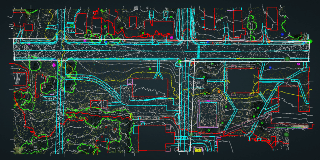
After collecting LiDAR data, the next critical step is to process and analyze the information to extract valuable insights and create meaningful visualizations. This process typically involves several stages, ensuring the accuracy, reliability, and usability of the final outputs. Here are the key aspects to consider when processing and analyzing LiDAR data:
Data preprocessing: Perform initial quality control and data cleaning to identify and remove any outliers, errors, or noise present in the raw LiDAR point cloud. This step may involve filtering, smoothing, or interpolating the data to enhance its overall quality and consistency.
Georeferencing and coordinate transformation: Convert the LiDAR data into a suitable coordinate system and reference frame to align it with other geospatial datasets and ensure accurate spatial representation. This process typically involves integrating the LiDAR data with GPS and IMU information collected during the survey.
Classification and segmentation: Assign each LiDAR point to a specific class or category based on its attributes, such as elevation, intensity, or return number. This step is crucial for identifying different types of features and objects within the dataset, such as buildings, vegetation, or water bodies.
Feature extraction and analysis: Extract relevant features and patterns from the classified LiDAR data to address specific project objectives or research questions. This may involve calculating various metrics, such as tree height, canopy cover, or building density, to inform decision-making and resource management.
Terrain modeling and visualization: Generate digital elevation models (DEMs), digital surface models (DSMs), or other types of 3D representations to visualize the LiDAR data and facilitate further analysis. These models can be used to assess topography, identify drainage patterns, or evaluate potential development sites.
Integration with other geospatial datasets: Combine the processed LiDAR data with other relevant geospatial information, such as aerial imagery, satellite data, or GIS layers, to create a comprehensive and contextual understanding of the study area.
Quality assurance and validation: Perform rigorous quality control and validation procedures to ensure the accuracy and reliability of the processed LiDAR data and derived products. This may involve comparing the LiDAR data with ground control points, field measurements, or other independent datasets.
Data dissemination and reporting: Package the processed LiDAR data, analysis results, and visualizations into a user-friendly format for dissemination to stakeholders or integration into decision-support systems. This may involve creating maps, reports, or interactive web applications to facilitate data exploration and interpretation.
By following these steps to process and analyze LiDAR data, you can unlock valuable insights, generate actionable information, and inform better decision-making across various industries and applications. Proper data processing and analysis are essential for maximizing the value and utility of your LiDAR survey.
Overcoming LiDAR Challenges for Optimal Results
Despite its numerous advantages, LiDAR technology does present certain challenges that may impact data quality, efficiency, and applicability. By understanding these challenges and implementing appropriate solutions, you can successfully overcome them and ensure optimal outcomes for your LiDAR survey. Here are some common challenges and their corresponding solutions:
1. High Data Volume
Challenge: LiDAR surveys generate vast amounts of data, which can be challenging to store, process, and analyze.
Solution: Utilize data compression techniques, efficient data storage solutions, and parallel processing capabilities to handle large LiDAR datasets more effectively.
2. Data Noise and Errors
Challenge: The presence of noise or errors in the raw LiDAR point cloud can impact the accuracy and reliability of the derived products.
Solution: Implement robust preprocessing and quality control measures, such as filtering, smoothing, or outlier removal, to improve the overall quality of the LiDAR data.
3. Atmospheric Interference
Challenge: Factors like weather conditions, dust, or fog can impact the performance of LiDAR systems, leading to reduced data quality or increased data uncertainty.
Solution: Schedule LiDAR surveys during optimal weather conditions and consider using advanced sensors with higher sensitivity or better atmospheric correction capabilities.
4. Complex Terrain and Vegetation
Challenge: Dense vegetation, steep terrain, or other challenging environments can impact the performance of LiDAR systems and the accuracy of the collected data.
Solution: Utilize LiDAR systems with higher point density or pulse repetition rates, and implement advanced classification and segmentation techniques to better differentiate between ground and non-ground points.
5. Limited Data Accessibility
Challenge: Some regions may have limited data availability due to restrictions, privacy concerns, or lack of LiDAR coverage.
Solution: Collaborate with relevant stakeholders, utilize open data sources, or consider alternative remote sensing technologies to obtain the required data.
6. Cost Considerations
Challenge: The initial investment in LiDAR equipment and data processing can be significant, especially for smaller projects or organizations with limited budgets.
Solution: Explore cost-sharing opportunities, partnerships, or grants to help offset the costs of LiDAR surveys and data processing. Additionally, consider outsourcing data processing to specialized service providers to reduce in-house expenses.
7. Technical Expertise
Challenge: Processing and analyzing LiDAR data requires specialized skills and knowledge, which may be a challenge for some organizations or individuals.
Solution: Invest in training and capacity-building initiatives, or collaborate with experienced professionals or service providers to ensure the effective processing and analysis of LiDAR data.
By addressing these common challenges and implementing the appropriate solutions, you can maximize the benefits of LiDAR technology and ensure the successful completion of your survey and data analysis objectives.
Future Developments in Aerial LiDAR
The realm of aerial LiDAR is in a state of constant evolution and progression, leading to the development of more innovative and effective techniques for the acquisition and analysis of data. In this segment, we will delve into some of the intriguing advancements in aerial LiDAR technology that hold the potential to radically transform the way we obtain, process, and utilize LiDAR data. The future of aerial LiDAR appears brighter than ever, with fresh sensor technologies and cutting-edge data processing methods leading the way. Join us as we explore the latest patterns and breakthroughs in aerial LiDAR and what they portend for the industry at large.
The Future of Aerial LiDAR Technology
Aerial LiDAR technology continues to evolve, driven by advancements in hardware and software. The future of aerial LiDAR is likely to be shaped by the following trends:
- Integration with other remote sensing technologies: Combining aerial LiDAR with other remote sensing methods, such as photogrammetry and hyperspectral imaging, can provide richer datasets and more comprehensive insights.
- Increased automation: Advances in machine learning and artificial intelligence will enable more efficient processing and analysis of LiDAR data, reducing the need for manual interpretation.
- Smaller, more affordable systems: As technology advances, LiDAR systems will become smaller, lighter, and more affordable, making them accessible to a broader range of users and applications.
- Drone-based LiDAR: The integration of LiDAR systems with unmanned aerial vehicles (UAVs) will enable more flexible, cost-effective surveying solutions for smaller-scale projects and hard-to-reach areas.
By harnessing the power of aerial LiDAR technology, industries across the globe can unlock valuable insights, optimize resources, and make more informed decisions, ultimately contributing to a more sustainable and efficient future.
Enhanced Accuracy and Real-Time Data Processing
As technology continues to advance, aerial LiDAR systems will benefit from improved accuracy and real-time data processing capabilities. These enhancements will enable even more precise measurements and faster decision-making for various applications.
- Higher point density: As the resolution of LiDAR sensors improves, they will be able to capture more data points per square meter. This increase in point density will result in even more detailed and accurate 3D models of the terrain.
- Real-time processing: Developments in computing power and data processing algorithms will enable LiDAR systems to process data in real-time, providing immediate insights and allowing for rapid adjustments to survey plans or project designs.
- Improved GNSS/IMU integration: Enhanced integration between LiDAR systems and GNSS (Global Navigation Satellite System) receivers and IMUs will result in more accurate georeferencing of the collected data, further improving the quality and reliability of LiDAR-derived products.
Additional Future Applications of LiDAR
As technology continues to evolve, so do the potential applications of aerial LiDAR. In this section, we’ll explore some of the emerging and future applications that are expected to shape the way we use aerial LiDAR technology in the coming years.
Autonomous Vehicles
One of the most promising applications of aerial LiDAR is in the development of autonomous vehicles. These vehicles rely on accurate and up-to-date mapping data to navigate safely and efficiently. Aerial LiDAR can provide high-resolution, real-time maps to support the complex decision-making processes required for self-driving cars.
Smart Cities
As urban populations grow, cities are increasingly turning to technology to optimize their infrastructure and services. Aerial LiDAR can provide crucial data for smart city initiatives, such as traffic management, waste disposal, and energy consumption. By mapping and monitoring urban environments, city planners can develop more sustainable and efficient urban ecosystems.
Precision Agriculture
In agriculture, aerial LiDAR can be used to assess crop health, identify areas in need of irrigation or fertilization, and monitor pest infestations. By providing detailed information on the health and growth of crops, farmers can optimize their resources and increase yields, ultimately contributing to global food security. To get an overview of Precision Agriculture and what the future holds for farmers, check out this article.
Climate Change Research
Aerial LiDAR is an essential tool for studying the impacts of climate change on the earth’s surface. By measuring changes in elevation, vegetation, and coastal areas, scientists can better understand the effects of rising sea levels, melting ice caps, and other consequences of climate change. This information is crucial for the development of mitigation and adaptation strategies, as illustrated by the environmental applications of LiDAR and its use in climate change research.
Disaster Management and Response
Aerial LiDAR can be used to assess the impacts of natural disasters, such as floods, landslides, and earthquakes. By providing accurate and timely data on affected areas, emergency responders can prioritize their efforts and allocate resources more effectively, potentially saving lives and reducing the overall impact of disasters. The use of LiDAR drones for mapping disaster zones is a new approach to disaster relief that demonstrates the technology’s potential in this field.
Archaeology and Cultural Heritage Preservation
In archaeology, aerial LiDAR can reveal previously undiscovered historical sites and structures hidden beneath vegetation or soil. This technology can help researchers map and analyze ancient landscapes, leading to new insights into human history. Additionally, aerial LiDAR can be used to monitor and protect cultural heritage sites from damage or decay. For example, LiDAR drones have been used to discover lost Mayan temples in Mexico, revolutionizing archaeology and showcasing the potential of this technology in the preservation of cultural heritage.

Outsourcing LiDAR Work: Costs and Benefits
When considering the implementation of LiDAR technology in your project, one option is to outsource the work to an outside agency that specializes in LiDAR data acquisition and processing. In this section, we’ll discuss the expected costs of outsourcing LiDAR work, the benefits of outsourcing, and why choosing a company like Blue Falcon Aerial can be advantageous for your project.
Costs of Outsourcing LiDAR Work
The costs of outsourcing LiDAR work can vary depending on the scope of the project, the type of LiDAR technology being used, and the specific services required. Some factors that can influence the cost of outsourcing include:
Data acquisition: The process of collecting LiDAR data, typically through aerial or ground-based surveys. Costs can be influenced by factors such as the size of the survey area, the resolution and accuracy required, and the complexity of the terrain.
Data processing: After LiDAR data is collected, it must be processed and converted into a usable format. This can involve tasks such as point cloud registration, noise filtering, and feature extraction. The cost of data processing can be affected by the size of the dataset, the complexity of the analysis, and the level of detail required in the final output.
Deliverables: The specific products or outputs generated from the processed LiDAR data, such as digital elevation models (DEMs), 3D models, or contour maps. The cost of producing these deliverables can be influenced by factors such as the level of detail required and the complexity of the data.
In general, outsourcing LiDAR work can range from a few thousand dollars for smaller, less complex projects to tens or even hundreds of thousands of dollars for larger, more complex projects. It’s important to obtain quotes from multiple providers to ensure you’re getting the best value for your investment.
Benefits of Outsourcing LiDAR Work
There are several benefits to outsourcing LiDAR work to an outside agency, including:
Expertise: By working with a specialized LiDAR service provider, you can benefit from their extensive experience and knowledge of the technology, ensuring that your project is executed efficiently and accurately.
Cost savings: Outsourcing can save you the expense of purchasing and maintaining your own LiDAR equipment, as well as the cost of hiring and training specialized personnel.
Flexibility: Outsourcing allows you to scale your LiDAR needs up or down as your project requirements change, without the need for large capital investments or long-term commitments.
Time savings: By outsourcing your LiDAR work, you can focus on your core business activities and leave the data acquisition and processing to the experts, freeing up valuable time and resources.
Why Choose Blue Falcon Aerial?
Blue Falcon Aerial is a trusted LiDAR service provider that specializes in aerial LiDAR data acquisition and processing. By choosing Blue Falcon Aerial for your LiDAR needs, you can benefit from:
High-quality deliverables: Blue Falcon Aerial offers a range of LiDAR deliverables, including high-resolution orthophotos, digital elevation models (DEMs), and 3D models, ensuring that you receive the most accurate and detailed outputs for your project.
Expertise: The team at Blue Falcon Aerial has extensive experience in the field of LiDAR technology, allowing them to provide expert guidance and support throughout the entire process, from data acquisition to final deliverables.
Competitive pricing: Blue Falcon Aerial offers competitive pricing for their LiDAR services, ensuring that you receive the best value for your investment.
By outsourcing your LiDAR work to Blue Falcon Aerial, you can be confident that you’re working with a reliable and experienced partner that is dedicated to helping you achieve your project goals. Their commitment to quality, accuracy, and customer satisfaction ensures that your LiDAR data will be delivered on time and within budget, allowing you to focus on making informed decisions and driving your project forward.
Aerial LiDAR technology has proven to be a valuable and versatile tool with a wide range of applications and benefits across various industries. As the technology continues to evolve, we can anticipate even more innovative uses and opportunities for aerial LiDAR in the future. If you’re interested in learning more about how LiDAR can benefit your projects or you’re in need of professional aerial services, don’t hesitate to contact Blue Falcon Aerial at https://www.bluefalconaerial.com/home/contact/. To further expand your knowledge on related topics, we recommend reading The Ultimate Guide to Drone Photogrammetry and Orthomosaics and Soaring High: A Comprehensive Guide to Building and Growing Your Drone Business.