In recent years, LiDAR planimetrics have emerged as a powerful tool for mapping and analyzing the Earth’s surface, providing businesses and organizations with accurate and detailed information to support better decision-making. As the demand for high-quality spatial data increases, understanding how LiDAR planimetrics can save you time and money is becoming more critical than ever.
Key Takeaways
- LiDAR Planimetrics for Accurate Mapping: LiDAR planimetrics use laser technology for precise, high-resolution mapping of the Earth’s surface, including both natural and man-made features.
- Efficiency in Urban Planning and Infrastructure: These maps are essential in urban planning, offering a clear representation of existing conditions for better infrastructure development.
- Environmental Management Applications: They aid in environmental management by identifying impacts on natural resources and monitoring changes.
- Utility in Archaeology and Cultural Heritage: LiDAR planimetrics assist in uncovering and preserving historical sites and structures.
- Mining and Geological Benefits: In mining, they help in identifying geological features and resource estimation.
- Integrating Aerial Photos for Enhanced Accuracy: Aerial photographs complement LiDAR data, leading to more detailed and accurate mapping.
- Cost-Effective and Time-Saving Technology: The technology offers cost savings and time efficiency in various mapping projects.
- Supports Informed Decision-Making: Provides high-resolution data for better decision-making in diverse fields.
- Versatile Across Various Industries: Its applicability spans multiple sectors, including construction, environmental management, and more.
- Seamless Data Integration with GIS: The digital nature of LiDAR data allows easy integration with GIS and other remote sensing technologies.
- Blue Falcon Aerial’s Expertise in LiDAR Planimetrics: The company offers professional, customized LiDAR mapping services, ensuring quality and efficiency.
What are LiDAR Planimetrics?
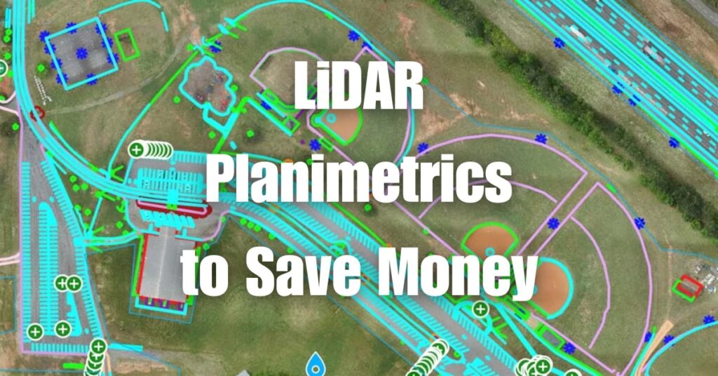
LiDAR, or Light Detection and Ranging, is a remote sensing technology that uses laser light to measure distances and create accurate, high-resolution digital elevation models of the Earth’s surface. LiDAR planimetrics specifically refers to the process of extracting two-dimensional features from LiDAR data, such as buildings, roads, and other man-made structures, as well as natural features like rivers and vegetation boundaries.
Key Characteristics of Planimetric Maps
Planimetric Map Features
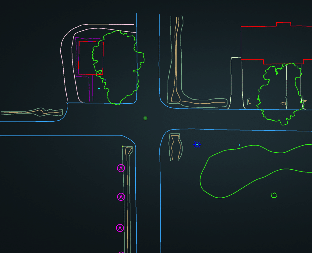
Planimetric maps are two-dimensional representations of the Earth’s surface, showing only horizontal positions of features without any elevation information. They display various man-made and natural elements, such as roads, buildings, water bodies, and vegetation boundaries. These maps provide valuable information for decision-makers in a wide range of industries.
Absence of Relief Information
A significant characteristic of planimetric maps is the absence of relief or elevation information. Unlike topographic maps, which display the Earth’s surface with contour lines and elevation data, planimetric maps focus solely on horizontal positions and do not show any variations in the terrain.
What Does a Planimetric Map Show?
A planimetric map displays the horizontal positions of various features on the Earth’s surface, such as buildings, roads, rivers, and other man-made and natural structures. These maps help users understand the spatial relationships between different elements within a specific area, enabling more informed decision-making in urban planning, environmental management, and other industries.
Uses and Applications of Planimetric Maps
Urban Planning and Infrastructure
Planimetric maps are invaluable tools for urban planners and engineers working on infrastructure projects. They provide a clear and accurate representation of existing conditions, enabling better decision-making when designing new developments or updating existing ones.
Environmental Management
In environmental management, planimetric maps help identify potential impacts on natural resources and ecosystems. They can be used to delineate wetlands, monitor deforestation, and assess potential risks related to flooding or erosion.
Archaeology and Cultural Heritage
Archeologists and cultural heritage professionals use planimetric maps to study and preserve historical sites. These maps can help identify previously undiscovered structures or features, providing valuable insights into the past.
Mining and Geology
In the mining and geology sector, planimetric maps are essential for identifying geological features and estimating mineral resources. They aid in planning and monitoring mining operations while minimizing the environmental impact.
Application of Aerial Photos in Planimetric Mapping
Aerial photographs play a crucial role in creating planimetric maps. They provide high-resolution imagery that can be used in conjunction with LiDAR data to extract accurate information about various features on the Earth’s surface. This combination of technologies allows for more precise and detailed mapping results.
Benefits of LiDAR Planimetrics
Improved Accuracy
LiDAR planimetrics offer unparalleled accuracy when compared to traditional mapping methods. This high level of precision allows for better decision-making and reduces the chances of errors in project planning and execution.
Speed and Efficiency
The speed at which LiDAR data can be collected and processed is a significant advantage over traditional mapping methods. This increased efficiency translates to cost savings and faster project completion times.
Cost Savings
By leveraging LiDAR planimetrics, organizations can save time and money on their mapping projects. The technology’s accuracy and efficiency mean fewer resources are needed for data collection and processing, resulting in overall cost savings.
Enhanced Decision-Making
The high-resolution, accurate data provided by LiDAR planimetrics enables better decision-making in various industries. This information helps organizations to plan more effectively, minimizing risks and maximizing potential benefits.
Versatility
LiDAR planimetrics can be utilized in a wide range of industries, from urban planning and infrastructure to environmental management and archaeology. This versatility means that organizations can leverage LiDAR planimetric data to solve a variety of challenges and improve decision-making processes.
Enhanced Data Integration
The digital nature of LiDAR planimetric data allows for seamless integration with other technologies, such as Geographic Information Systems (GIS) and remote sensing. This compatibility enables organizations to utilize a wealth of information and create comprehensive maps that inform decision-making more effectively.
Why Choose Blue Falcon Aerial for Your LiDAR Planimetric Needs
Blue Falcon Aerial is a trusted provider of aerial mapping services, including LiDAR planimetrics. They offer a variety of benefits that make them the ideal choice for your mapping needs:
- Expertise: Blue Falcon Aerial’s team of professionals has extensive experience in the industry, ensuring that you receive the highest quality data for your projects.
- Advanced Technology: Blue Falcon Aerial uses state-of-the-art LiDAR sensors and aerial platforms to collect and process data, providing highly accurate and detailed planimetric maps.
- Customized Solutions: Blue Falcon Aerial understands that each project is unique, so they work closely with clients to develop customized solutions tailored to their specific requirements.
- Efficient Turnaround: The team at Blue Falcon Aerial is committed to providing rapid data collection and processing, ensuring that clients receive their deliverables in a timely manner.
- Competitive Pricing: Blue Falcon Aerial offers competitive pricing for their services, ensuring that clients receive the best value for their investment.
By choosing Blue Falcon Aerial for your LiDAR planimetric needs, you can be confident that you are partnering with a professional, reliable, and knowledgeable provider. Their expertise, advanced technology, and commitment to customer satisfaction ensure that your mapping projects will be completed accurately, efficiently, and cost-effectively.
To learn more about Blue Falcon Aerial’s LiDAR planimetric services and how they can benefit your organization, visit Blue Falcon Aerial’s Deliverables page.
In conclusion, LiDAR planimetrics offer numerous benefits, including improved accuracy, speed, efficiency, cost savings, and enhanced decision-making capabilities. By leveraging this cutting-edge technology, businesses and organizations can make better-informed decisions in various industries such as urban planning, environmental management, archaeology, and mining. To learn more about LiDAR technology and its applications, we encourage you to visit Aerial LiDAR 101: An Introduction to its Applications and Benefits.
If you need any drone services or are considering implementing LiDAR planimetrics for your organization, don’t hesitate to contact Blue Falcon Aerial. Our team of experts is ready to assist you in harnessing the power of LiDAR technology to save time and money on your projects.