Vegetation management is a critical aspect of maintaining the safety and efficiency of powerline networks. Traditional methods of vegetation management can be time-consuming, labor-intensive, and expensive. However, LiDAR technology offers a more efficient, cost-effective solution for powerline vegetation management. This article will discuss the benefits of using LiDAR for vegetation management and how it can significantly reduce costs and improve efficiency.
What is LiDAR and How Does it Work?
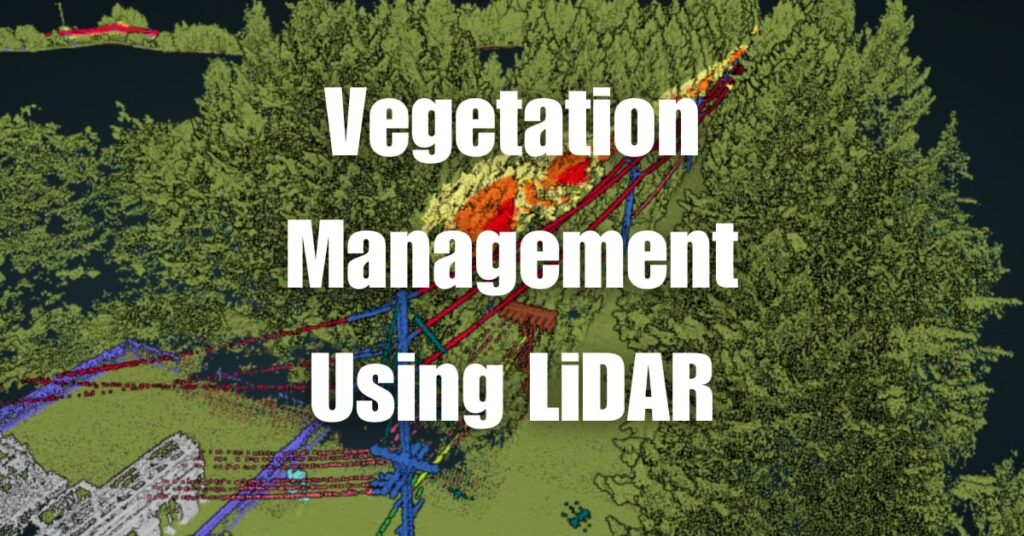
LiDAR (Light Detection and Ranging) is a remote sensing technology that uses laser light to measure distances and create detailed, accurate 3D models of the environment. A LiDAR system typically includes a laser, a scanner, and a specialized GPS receiver. The system sends out laser pulses, which bounce off objects and return to the sensor. By measuring the time it takes for the laser pulse to return, the system can calculate the distance between the sensor and the object.
The Benefits of Using LiDAR for Vegetation Management
LiDAR technology offers several advantages that make it an ideal solution for powerline vegetation management. By incorporating LiDAR into their vegetation management strategies, utility companies can experience numerous benefits, including:
Enhanced Accuracy and Precision in Data Collection
Traditional methods of vegetation management, such as manual inspections or ground-based surveys, often produce inconsistent results and are prone to errors. LiDAR technology, on the other hand, provides highly accurate and precise measurements of vegetation and its proximity to powerlines. This level of detail enables utility companies to make informed decisions and improve their risk assessments, ensuring that their powerline networks remain safe and efficient.
Increased Efficiency in Vegetation Management Tasks
LiDAR technology streamlines the data collection process, allowing utility companies to complete vegetation management tasks more efficiently. LiDAR-equipped drones can quickly cover large areas and collect detailed, high-resolution data, substantially reducing the time and resources required for traditional methods like manual inspections and aerial photography. This increased efficiency ultimately leads to cost savings and improved overall performance.
Reduced Costs and Resource Requirements
Implementing LiDAR for vegetation management can result in significant cost savings for utility companies. By providing accurate, high-resolution data and reducing the need for manual inspections and ground-based surveys, LiDAR technology can lower labor costs and minimize time spent on vegetation management tasks. Additionally, the increased efficiency in data collection allows for better resource allocation, resulting in more effective vegetation management strategies.
Improved Safety and Risk Mitigation
Safety is a top priority for utility companies when managing vegetation around powerlines. LiDAR technology can help identify potential hazards, such as overgrown vegetation or tree branches that may be too close to powerlines. Early detection of these hazards allows utility companies to take appropriate action to prevent power outages, fires, or other safety risks, ensuring the safety of both their infrastructure and the public.
Real-World Applications of LiDAR in Powerline Vegetation Management
Utility companies worldwide have successfully implemented LiDAR technology for vegetation management, resulting in considerable cost savings, improved efficiency, and enhanced safety. Some real-world applications of LiDAR in powerline vegetation management include:
Risk Assessment and Prioritization
LiDAR data can be instrumental in helping utility companies identify high-risk areas that require immediate attention. By pinpointing these areas, utility companies can prioritize their vegetation management efforts and allocate resources more efficiently, ensuring the safety and reliability of their powerline networks.
Remote Sensing and Monitoring
LiDAR-equipped drones can effectively monitor vegetation growth and proximity to powerlines in hard-to-reach or inaccessible areas. This remote sensing capability reduces the need for manual inspections, increases safety for inspection crews, and provides utility companies with valuable data to inform their vegetation management strategies.
Planning and Maintenance Optimization
Accurate, high-resolution LiDAR data can be used to plan and schedule vegetation management tasks effectively. By using this data, utility companies can ensure that resources are used optimally, and maintenance schedules are met, resulting in a more reliable powerline network.
Predictive Analytics and Proactive Management
By analyzing LiDAR data, utility companies can identify trends in vegetation growth and develop predictive models to anticipate potential issues before they become critical. This proactive approach to vegetation management allows utility companies to address problems before they escalate, reducing the risk of power outages, and minimizing the need for costly emergency response efforts.
In summary, the benefits of using LiDAR for vegetation management are numerous, and its real-world applications continue to demonstrate its value in maintaining safe and efficient powerline networks. By embracing this innovative technology, utility companies can optimize their vegetation management efforts, reduce costs, and improve overall performance.
How Blue Falcon Aerial Can Assist with Vegetation Management
Blue Falcon Aerial is a leading provider of drone services, including LiDAR-based vegetation management solutions. With a team of experienced professionals and cutting-edge technology, Blue Falcon Aerial is well-equipped to help utility companies optimize their vegetation management efforts and maintain the safety and efficiency of their powerline networks. Some of the ways Blue Falcon Aerial can assist you with vegetation management include:
Customized LiDAR Solutions
At Blue Falcon Aerial, we understand that each utility company has unique requirements and challenges when it comes to vegetation management. Our team will work closely with you to develop a customized LiDAR solution tailored to your specific needs, ensuring that you receive the most accurate and relevant data to inform your vegetation management strategies.
High-Quality Data Collection and Analysis
Our team of experts uses state-of-the-art LiDAR technology to collect high-resolution, accurate data on vegetation growth and its proximity to powerlines. We then analyze this data to identify potential hazards, high-risk areas, and other critical factors that may impact your powerline network’s safety and efficiency. This detailed analysis enables you to make informed decisions and prioritize your vegetation management efforts effectively.
Comprehensive Deliverables
Blue Falcon Aerial is committed to providing utility companies with comprehensive deliverables that offer valuable insights and actionable information. Our deliverables, as described on our Deliverables page, include high-resolution LiDAR point clouds, digital terrain models, and digital surface models, among others. These deliverables provide you with a clear and detailed understanding of the vegetation around your powerline infrastructure, allowing you to develop effective vegetation management plans.
Ongoing Support and Consultation
Our commitment to your success doesn’t end with the delivery of LiDAR data and analysis. Blue Falcon Aerial provides ongoing support and consultation services to help you implement your vegetation management strategies and address any challenges that may arise. Our team of experts is always available to answer your questions and provide guidance, ensuring that you get the most out of your investment in LiDAR technology.
In conclusion, Blue Falcon Aerial is a trusted partner for utility companies seeking to optimize their vegetation management efforts through the use of LiDAR technology. With our customized solutions, high-quality data collection and analysis, comprehensive deliverables, and ongoing support, you can be confident that your powerline network is protected and operating at peak efficiency. To learn more about how Blue Falcon Aerial can assist you with your vegetation management needs, please visit our contact page to get in touch with our team.
Conclusion: Embracing LiDAR for Enhanced Vegetation Management
In conclusion, LiDAR technology has proven to be a game-changer for powerline vegetation management. It offers enhanced accuracy, increased efficiency, reduced costs, and improved safety, making it a valuable tool for utility companies. By embracing LiDAR technology, organizations can optimize their vegetation management efforts and better protect their powerline infrastructure.
If you’d like to gain a deeper understanding of LiDAR and its numerous applications, we encourage you to read our comprehensive guide, Aerial LiDAR 101: An Introduction to its Applications and Benefits. This resource will provide you with valuable insights into how LiDAR technology can be effectively utilized in various industries and scenarios.
For any drone services you may need, including LiDAR-based vegetation management, don’t hesitate to reach out to Blue Falcon Aerial. You can contact us through our website by visiting this contact link. We look forward to assisting you in meeting your vegetation management needs and achieving outstanding results.