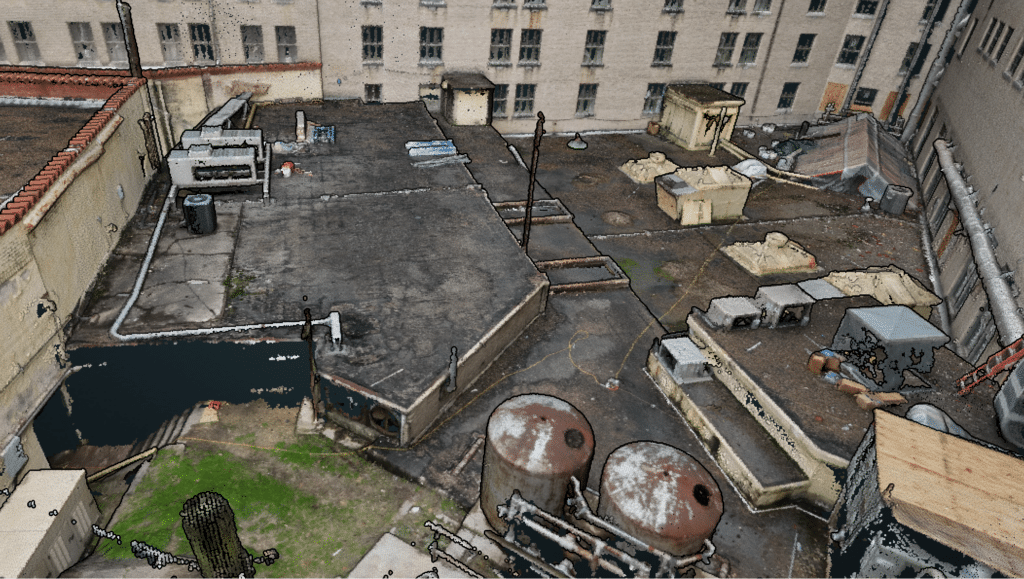
The integration of LiDAR and GIS has become a game-changer in the geospatial industry, offering unprecedented opportunities for spatial analysis and decision-making. This powerful combination is revolutionizing the way we collect, analyze, and visualize geospatial data, transforming the landscape of industries such as urban planning, environmental management, and infrastructure monitoring. In this article, we will explore the benefits of integrating LiDAR and GIS, delve into real-world examples, and examine the future trends that promise to further revolutionize geospatial analysis.
What is LiDAR?
LiDAR, or Light Detection and Ranging, is a remote sensing technology that utilizes laser light to measure distances and create detailed, accurate representations of the Earth’s surface. By emitting laser pulses and measuring the time it takes for the light to bounce back to the sensor, LiDAR systems are capable of generating high-resolution, three-dimensional point clouds. These point clouds represent the shape and structure of the Earth, including terrain, vegetation, and man-made structures.
LiDAR can be deployed using various platforms, such as ground-based, airborne (both manned and unmanned), and satellite-based systems. The choice of platform depends on factors like the desired resolution, project scale, and specific application. LiDAR has become an indispensable tool in numerous fields, including topography, forestry, agriculture, infrastructure, and archaeology, due to its ability to provide accurate, high-resolution data in a relatively short period.
What is GIS?
Geographic Information System (GIS) is a computer-based framework designed for capturing, managing, analyzing, and displaying geospatial data. It enables users to visualize, question, interpret, and understand spatial patterns, relationships, and trends in the world around us. GIS integrates various types of data, such as imagery, elevation, demographics, and infrastructure, into a single system to create comprehensive and interactive maps and models.
GIS plays a crucial role in various industries and sectors, including urban planning, environmental management, transportation, agriculture, and emergency response. By providing tools for spatial analysis, GIS allows decision-makers to make informed choices based on a comprehensive understanding of the spatial context. The technology has evolved over the years, and with the advent of web-based and mobile GIS applications, geospatial data has become more accessible and user-friendly, enabling a broader range of users to harness its potential.
LiDAR Usage in GIS
LiDAR data plays a significant role in GIS applications by providing highly accurate, three-dimensional information about the Earth’s surface. The high-resolution point clouds generated by LiDAR can be used to create Digital Elevation Models (DEMs), Digital Terrain Models (DTMs), and Digital Surface Models (DSMs), which serve as foundational layers in GIS projects. By incorporating LiDAR data, GIS analysts can perform more precise and comprehensive spatial analyses, leading to better-informed decision-making.
In addition to terrain modeling, LiDAR data is also used in GIS for various other applications, such as:
- Vegetation analysis and forestry management
- Hydrological modeling and floodplain mapping
- Infrastructure planning and inspection
- Urban planning and development
- Archaeological site detection and preservation
By integrating LiDAR data with other geospatial information, GIS professionals can derive valuable insights and uncover hidden patterns that would otherwise be difficult or impossible to detect using traditional methods.
Purpose of LiDAR for Mapping and GIS
The primary purpose of LiDAR in mapping and GIS is to provide highly accurate, detailed, and precise geospatial data that can be used to model and analyze the Earth’s surface. This data is invaluable for a wide range of applications, from infrastructure planning to environmental monitoring and resource management. Some of the key benefits that LiDAR offers for mapping and GIS include:
High-resolution data: LiDAR systems can capture data at a much higher resolution than other remote sensing technologies, such as aerial photography or satellite imagery. This level of detail allows for more accurate representations of the Earth’s surface and improved spatial analysis.
Speed and efficiency: LiDAR can collect vast amounts of data in a relatively short period, making it an efficient choice for large-scale mapping projects. This speed and efficiency are especially useful in time-sensitive applications, such as disaster response and recovery.
Versatility: LiDAR can be deployed on various platforms, including ground-based, airborne, and satellite systems, making it suitable for a wide range of applications and project scales.
Canopy penetration: LiDAR’s ability to penetrate vegetation canopies allows it to capture accurate terrain data even in heavily forested areas, which is particularly useful for forestry management and environmental monitoring.
By providing high-quality geospatial data, LiDAR serves as a critical tool in the GIS toolbox, enabling more effective and informed decision-making across numerous industries and applications.
Integration of LiDAR and GIS
The integration of LiDAR and GIS brings together the high-resolution, three-dimensional data generated by LiDAR systems with the powerful analytical capabilities of GIS. This combination offers numerous benefits for geospatial analysis and decision-making, including:
Improved Data Accuracy
By incorporating LiDAR data into GIS projects, analysts can significantly enhance the accuracy of their geospatial models and analyses. The high-resolution point clouds generated by LiDAR enable the creation of more detailed and accurate elevation models, which serve as the foundation for many GIS applications.
Enhanced Visualization and Analysis
The three-dimensional nature of LiDAR data allows for more advanced visualization and analysis techniques within GIS. Analysts can create 3D models, viewsheds, and fly-through animations that provide a more comprehensive understanding of the spatial context. This enhanced visualization can lead to better decision-making and improved communication of complex geospatial concepts.
Streamlining Workflows
The integration of LiDAR and GIS streamlines workflows by eliminating the need for manual data processing and conversion. Modern GIS software can seamlessly import, process, and analyze LiDAR data, making it easier for analysts to incorporate this valuable information into their projects.
Advanced Applications
The fusion of LiDAR and GIS enables the development of advanced applications that would be difficult or impossible to achieve using traditional methods. Examples include automated feature extraction, detailed vegetation analysis, and precise infrastructure modeling.
Working with LiDAR Data in ArcGIS
ArcGIS, a widely-used GIS software developed by Esri, offers extensive capabilities for working with LiDAR data. In this section, we will explore the various aspects of importing, processing, and analyzing LiDAR data within ArcGIS.
Importing LiDAR Data into ArcGIS
To import LiDAR data into ArcGIS, you can use the LAS dataset, which is a native format for storing and managing LiDAR point clouds. ArcGIS supports both LAS and zLAS (compressed LAS) files, enabling seamless integration of LiDAR data into your GIS projects.
LiDAR Data Formats and ArcGIS Compatibility
In addition to LAS and zLAS formats, ArcGIS also supports other common LiDAR data formats, such as LAZ (a popular open-source compression format) and E57 (a vendor-neutral format for 3D data exchange). By using compatible formats, you can easily incorporate LiDAR data from various sources into your ArcGIS projects.
LiDAR Classification in ArcGIS
LiDAR data points can be classified based on their attributes, such as elevation, intensity, and return number. ArcGIS offers tools for classifying LiDAR points into different categories, such as ground, buildings, vegetation, and water. This classification process allows for more efficient data management and analysis within your GIS projects.
Processing LiDAR Data in ArcGIS Pro
ArcGIS Pro, Esri’s next-generation GIS software, offers a range of tools and capabilities for processing and analyzing LiDAR data. With ArcGIS Pro, you can:
- Create digital elevation models (DEMs), digital terrain models (DTMs), and digital surface models (DSMs) from LiDAR point clouds.
- Perform advanced terrain analysis, such as slope, aspect, and hillshade calculations.
- Extract features, such as buildings and vegetation, using automated classification tools.
- Visualize and analyze LiDAR data in 3D, enabling more immersive and informative presentations.
By leveraging the powerful LiDAR processing capabilities of ArcGIS Pro, you can unlock the full potential of LiDAR data in your geospatial projects.
Real-world Examples of LiDAR-GIS Integration
The integration of LiDAR and GIS has revolutionized geospatial analysis in numerous industries and applications. Here are some real-world examples that demonstrate the power of LiDAR-GIS integration:
Urban Planning
City planners use LiDAR data in combination with GIS to create detailed 3D models of urban environments, enabling them to assess the impact of proposed developments, monitor changes in land use, and optimize infrastructure placement. LiDAR-GIS integration can also aid in identifying areas at risk from natural hazards, such as flooding or landslides, and developing appropriate mitigation measures.
Environmental Management
By integrating LiDAR data with GIS, environmental managers can accurately model and analyze vegetation, wildlife habitats, and hydrological features. This information is crucial for assessing the health of ecosystems, monitoring changes over time, and developing strategies for conservation and resource management.
Infrastructure Monitoring
LiDAR-GIS integration allows engineers and asset managers to create detailed, accurate models of infrastructure, such as roads, bridges, and utility networks. These models can be used for assessing the condition of assets, identifying potential issues, and planning maintenance and repair activities. LiDAR data can also be used for detecting and monitoring changes in infrastructure over time, such as subsidence or erosion.
Disaster Management
Emergency response agencies rely on LiDAR-GIS integration to create accurate, up-to-date situational awareness during disasters. By combining LiDAR data with other geospatial information, responders can assess the extent of damage, identify areas at risk, and prioritize resources for rescue and recovery operations.
Archaeology
Archaeologists use LiDAR-GIS integration to detect and map previously unknown archaeological sites, as well as monitor known sites for signs of degradation or looting. LiDAR’s ability to penetrate vegetation canopies and create detailed surface models allows researchers to identify subtle features that might be obscured by traditional remote sensing methods.
Future Trends in LiDAR and GIS Integration
As LiDAR technology continues to evolve, and GIS software becomes more advanced, the integration of LiDAR and GIS is poised to offer even more powerful capabilities for geospatial analysis. Some of the emerging trends in LiDAR-GIS integration include:
Higher-resolution data: Advances in LiDAR sensor technology are expected to enable the capture of even higher-resolution data, further improving the accuracy and detail of geospatial models and analyses.
Machine learning and artificial intelligence: The integration of machine learning and artificial intelligence algorithms with LiDAR-GIS workflows has the potential to significantly enhance the efficiency and accuracy of feature extraction, classification, and analysis processes.
Real-time data processing: As LiDAR systems become faster and more efficient, the ability to process and analyze data in real-time will become increasingly important. This capability will enable more dynamic decision-making in fields such as disaster response, transportation, and infrastructure management.
Increased accessibility: With the growth of open data initiatives and the development of more affordable LiDAR sensors, access to high-quality LiDAR data is expected to increase, enabling a broader range of users to harness the power of LiDAR-GIS integration.
As these trends continue to shape the future of LiDAR and GIS, the potential for groundbreaking applications and insights will only continue to grow.
The integration of LiDAR and GIS has undoubtedly transformed the geospatial industry, providing a powerful combination that enhances data accuracy, visualization, and analysis. As we have seen in various real-world examples, this fusion of technologies is driving innovation and improvements across multiple sectors, from urban planning to environmental management and beyond. The future of LiDAR and GIS integration is poised for continued growth, with new applications and advancements on the horizon. To learn more about the exciting potential of LiDAR technology, we encourage you to explore Aerial LiDAR 101: An Introduction to its Applications and Benefits. If you are in need of professional drone services or assistance with your geospatial projects, don’t hesitate to contact Blue Falcon Aerial for expert support and guidance.


