Standing out requires not just innovation but also the ability to visualize and implement that innovation efficiently. Advanced 3D modeling with drones offers businesses an unparalleled edge, transforming how industries like agriculture, construction, and real estate visualize projects and make data-driven decisions. This article dives into the transformative power of 3D drone modeling, showcasing how it can elevate your business to new heights of efficiency and insight.
Key Takeaways
- Advanced 3D modeling with drones enables businesses to capture detailed aerial data and imagery, transforming operations across industries like agriculture, construction, real estate, and environmental monitoring.
- The integration of drone technology in 3D modeling marks a significant evolution, making 3D modeling more accessible and cost-effective for businesses.
- 3D drone modeling utilizes technologies such as photogrammetry, orthomosaics, multispectral analysis, and thermal analysis to provide comprehensive insights into physical objects and landscapes.
- Implementing 3D drone modeling requires understanding business needs, choosing the right drone and software, and investing in professional training and support to ensure success.
- Blue Falcon Aerial offers a suite of services, including detailed needs assessments, custom SOP development, equipment selection guidance, professional training and support, and data analysis, to help businesses integrate advanced 3D drone modeling and achieve actionable insights.
The Evolution of 3D Modeling Technology
The journey of 3D modeling technology is a testament to human ingenuity and technological advancement. Initially rooted in the domains of engineering and entertainment, 3D modeling has expanded its reach, influencing numerous industries with its capability to create detailed digital representations of physical objects and environments.
A Brief History of 3D Modeling in Various Industries
From the early days of simple wireframe models to the sophisticated, highly detailed models of today, 3D modeling has undergone significant evolution. In engineering, it has been instrumental in simulating complex structures and systems. In entertainment, it has brought to life stunning visual effects and animated characters that captivate audiences worldwide.
The Advent of Drone Technology in 3D Modeling
The integration of drone technology has marked a new era in 3D modeling. Drones, equipped with advanced sensors and cameras, offer a new perspective by capturing data from the sky. This innovation has not only expanded the capabilities of 3D modeling but also made it more accessible and cost-effective for businesses across various sectors.
Understanding 3D Drone Modeling
3D drone modeling represents the convergence of drone technology and 3D modeling, providing a powerful tool for businesses to capture and analyze data like never before.
What is 3D Drone Modeling?
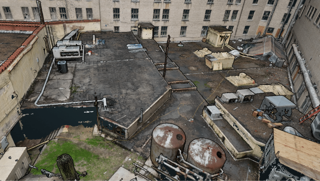
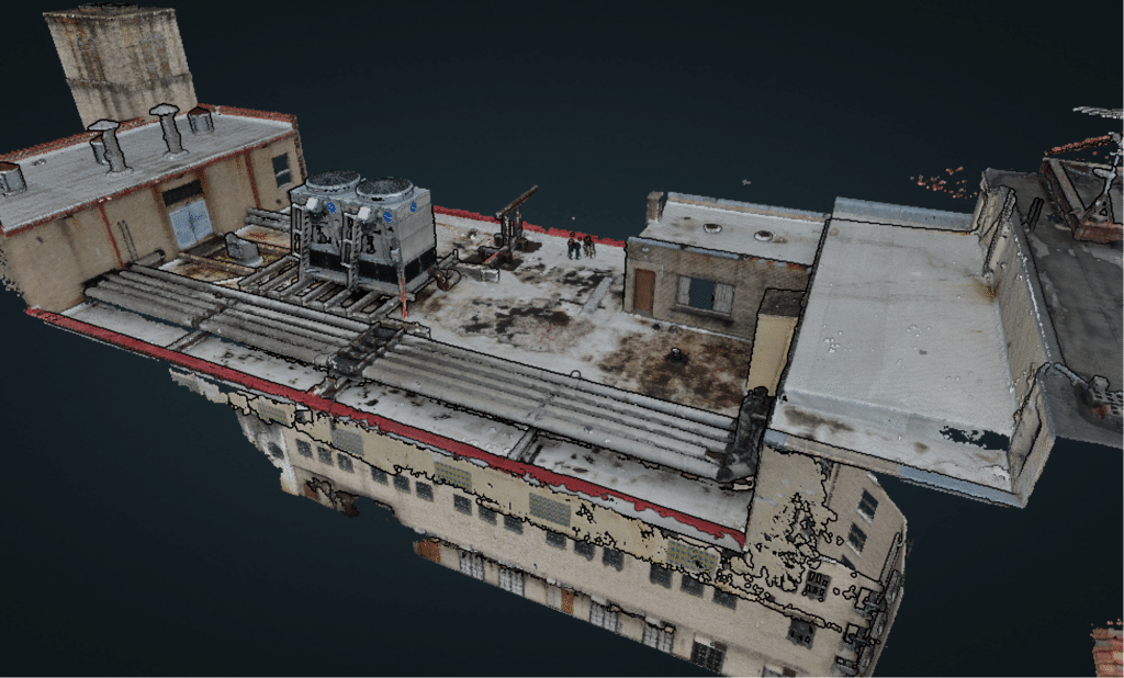
3D drone modeling involves using drones to capture aerial imagery and data, which is then processed to create three-dimensional models of physical objects and landscapes. This technique allows for the detailed analysis and visualization of features not easily accessible or visible from the ground.
How Does it Work? The Basics of Photogrammetry, Orthomosaics, Multispectral, and Thermal Analysis
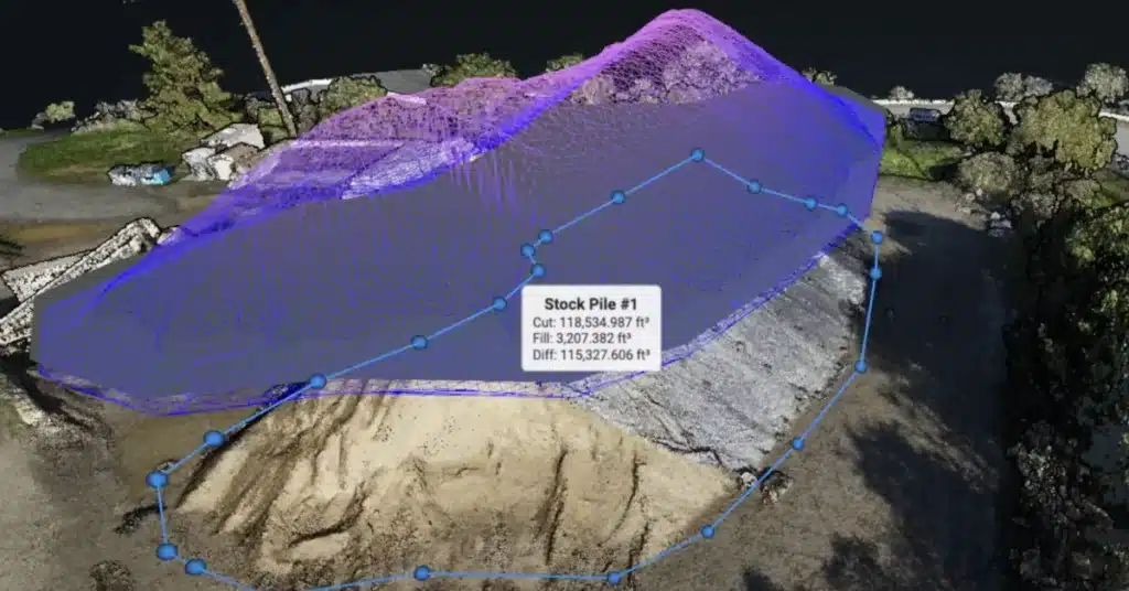
Photogrammetry: This process uses photographs from drones to measure and create 3D models of physical objects and terrains. By analyzing the overlaps and differences in images, photogrammetry can construct highly accurate 3D representations.
Orthomosaics: An orthomosaic is a large, map-quality image made by combining several smaller images. It provides a detailed, top-down view of a landscape, essential for mapping and analysis.
Multispectral Analysis: This involves capturing data from different light spectrums to analyze various surface characteristics. It’s particularly useful in agriculture for assessing plant health and in environmental studies for monitoring vegetation and water bodies.
Thermal Analysis: Using thermal sensors, drones can detect heat variances in objects and environments. This is invaluable for energy audits, search and rescue operations, and environmental monitoring, providing insights into thermal efficiencies and wildlife patterns.
| Technology | Description | Applications |
|---|---|---|
| Photogrammetry | Creating 3D models from photographs | Surveying, archaeology, engineering |
| Orthomosaics | Large, detailed images from smaller photos | Agriculture, urban planning, disaster management |
| Multispectral Analysis | Analyzing different light spectrums | Crop health, water quality, forest management |
| Thermal Analysis | Detecting heat differences | Energy audits, search and rescue, environmental monitoring |
By leveraging these technologies, businesses can gain unprecedented insights into their operations, assets, and the environment, driving efficiency and innovation.
Applications of 3D Drone Modeling in Business
The versatility of 3D drone modeling has made it an invaluable tool across a wide range of industries. By providing detailed and accurate models of physical spaces, businesses can optimize their operations, enhance decision-making, and improve overall efficiency.
Agriculture: Crop Monitoring and Management
In the agricultural sector, 3D drone modeling revolutionizes how farmers monitor crop health, manage resources, and plan for future growth. Detailed models and analyses allow for targeted interventions, maximizing yield and reducing waste.
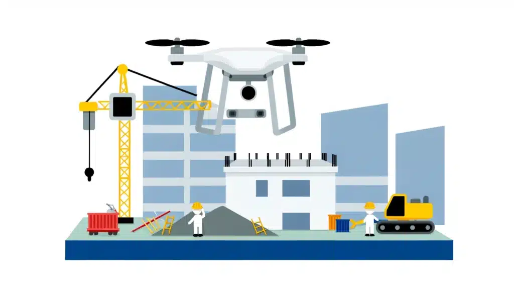
Construction: Site Planning and Progress Tracking
For construction projects, 3D drone modeling offers a bird’s-eye view of the entire site, aiding in precise planning and real-time progress tracking. It ensures that project timelines are adhered to and helps identify potential issues before they become costly problems.
Real Estate: Property Visualization
In real estate, 3D models created by drones offer potential buyers a comprehensive view of properties, enhancing the buying experience. These models provide a realistic representation of properties, aiding in marketing and sales efforts.
Environmental Monitoring: Analyzing Landscapes and Ecosystems
Environmental scientists and conservationists use 3D drone modeling to monitor changes in landscapes and ecosystems over time. This technology aids in the preservation of natural habitats and helps in the planning of sustainable development projects.
Implementing 3D Drone Modeling in Your Business
Adopting 3D drone modeling within your business operations can seem daunting, but with the right approach and resources, it can be seamlessly integrated to enhance your business capabilities.
Initial Considerations: Understanding Business Needs
Before implementing 3D drone modeling, it’s crucial to assess your business needs and how this technology can meet them. Whether it’s improving operational efficiency, enhancing data analysis, or providing better customer experiences, understanding your objectives is the first step.
Choosing the Right Drone and Software
Selecting the appropriate drone and software is critical to the success of your 3D modeling projects. Consider factors such as flight time, payload capacity, and the types of sensors needed to capture the required data.
| Factor | Consideration |
|---|---|
| Flight Time | Longer flight times allow for extensive data collection over large areas. |
| Payload Capacity | Determines the types of sensors and equipment the drone can carry. |
| Sensor Types | Choose based on the data needed, such as visual, multispectral, or thermal sensors. |
The Importance of Professional Training and Support
Professional training ensures that your team can effectively operate drones and analyze the collected data. Ongoing support from experts can help address any challenges that arise and ensure that you are getting the most out of your investment in 3D drone modeling technology.
By carefully considering these aspects and choosing a knowledgeable partner like Blue Falcon Aerial, businesses can unlock the full potential of 3D drone modeling to drive innovation and growth.
Blue Falcon Aerial’s Role in Your Success
Blue Falcon Aerial is dedicated to empowering businesses by integrating advanced 3D drone modeling into their operations. Our comprehensive suite of services is designed to meet the unique needs of each client, ensuring that the integration of drone technology adds value and drives growth.
Detailed Needs Assessment
Our process begins with a thorough understanding of your business operations, challenges, and objectives. This initial consultation is crucial for identifying the most impactful ways to utilize drone technology in your workflow.
Custom SOP Development
Leveraging our extensive experience, we craft a tailored Standard Operating Procedure (SOP) for drone operations. This plan ensures that drone integration aligns with your specific business needs, promoting efficiency and compliance.
Equipment Selection Guidance
Choosing the right drones and sensors is critical for the success of your 3D modeling projects. We guide you through this process, recommending equipment that fits your operational requirements and budget.
| Service | Description |
|---|---|
| Needs Assessment | Understand operations, challenges, and goals. |
| SOP Development | Tailor drone operations to business needs. |
| Equipment Guidance | Recommend drones and sensors for your needs. |
Professional Training and Support
Our commitment to your success extends beyond initial implementation. We provide comprehensive training to ensure your team is proficient in drone operations and data analysis. Ongoing support guarantees long-term success and adaptation to evolving drone technologies.
Transforming Data into Actionable Insights
The ultimate goal of 3D drone modeling is to transform raw data into actionable insights. Our team specializes in processing and analyzing the data collected, creating detailed reports, maps, and models that inform better business decisions.
By partnering with Blue Falcon Aerial, you gain access to not only cutting-edge drone technology but also a team of experts committed to your success. Together, we can elevate your business operations, making them more efficient, insightful, and competitive in today’s market.
As we’ve explored, advanced 3D modeling with drones is not just a technological advancement; it’s a business revolution. From the precision of photogrammetry and orthomosaics to the detailed analysis provided by multispectral and thermal imaging, the potential for businesses to improve efficiency, accuracy, and decision-making is immense. Blue Falcon Aerial is at the forefront of this revolution, offering a comprehensive suite of services designed to seamlessly integrate advanced 3D drone modeling into your business operations.
If you’re ready to harness the power of 3D drone modeling and transform your business operations, explore how Blue Falcon Aerial can make it happen. With our expert team, custom solutions, and commitment to your success, we’re here to guide you through every step of the process. To discuss integrating drones into your business, contact us today. Let’s take your business to new dimensions together.