Volumetric Calculation with LiDAR has become an essential tool in industries requiring precise volume measurements and efficient land management. LiDAR technology, when mounted on drones, allows professionals to collect accurate 3D data for a variety of applications. In this article, we will dive into the fundamentals of LiDAR, its advantages over traditional surveying methods, and its applications across different industries. We will also discuss the challenges and limitations of LiDAR-based volumetric calculations, software options for processing LiDAR data, and best practices for mastering volumetric calculations using this cutting-edge technology.
Understanding LiDAR Technology for Volumetric Calculation
What is LiDAR and How Does It Work?
LiDAR (Light Detection and Ranging) is a remote sensing technology that uses laser light to measure distances and generate accurate, high-resolution 3D data. A LiDAR system typically consists of a laser, a scanner, and a specialized GPS receiver. The system emits laser pulses towards the ground, which then bounce back after hitting objects or surfaces. By measuring the time it takes for the pulses to return, the system calculates the distance between the sensor and the object, creating a dense point cloud of spatial data.
How Accurate is LiDAR Technology for Calculating Volumes?
LiDAR technology is renowned for its accuracy and precision in calculating volumes. The high-resolution 3D data generated by LiDAR allows for measurements with a vertical accuracy of up to 10-15 centimeters, depending on the sensor and environmental conditions. This level of accuracy enables professionals to make informed decisions when planning projects, managing resources, and monitoring land use changes.
Advantages of Using LiDAR for Volumetric Measurement
Accuracy and Precision
One of the primary advantages of using LiDAR for volumetric measurements is its unparalleled accuracy and precision. Traditional surveying methods, such as photogrammetry, often require ground control points and manual calculations, which can introduce errors and inconsistencies. LiDAR technology, on the other hand, generates highly accurate 3D data that can be easily processed using specialized software, resulting in precise volume calculations.
Time and Cost Efficiency
LiDAR technology, when mounted on drones, offers significant time and cost savings compared to traditional surveying methods. Drone-based LiDAR surveys can cover large areas quickly and efficiently, reducing the need for ground personnel and eliminating the risk of human error. Additionally, the high-resolution data collected can be processed in a fraction of the time required by conventional methods, allowing for faster project turnaround and reduced costs.
Safety Improvements
Using LiDAR technology for volumetric calculations also improves safety by reducing the need for ground personnel to access potentially hazardous areas, such as steep slopes, unstable terrain, or active construction sites. Drone-based LiDAR surveys can be conducted remotely, minimizing the risk of accidents and injuries while still providing accurate and reliable data for decision-making.
Applications of Volumetric Calculations in Various Industries
Mining and Quarrying
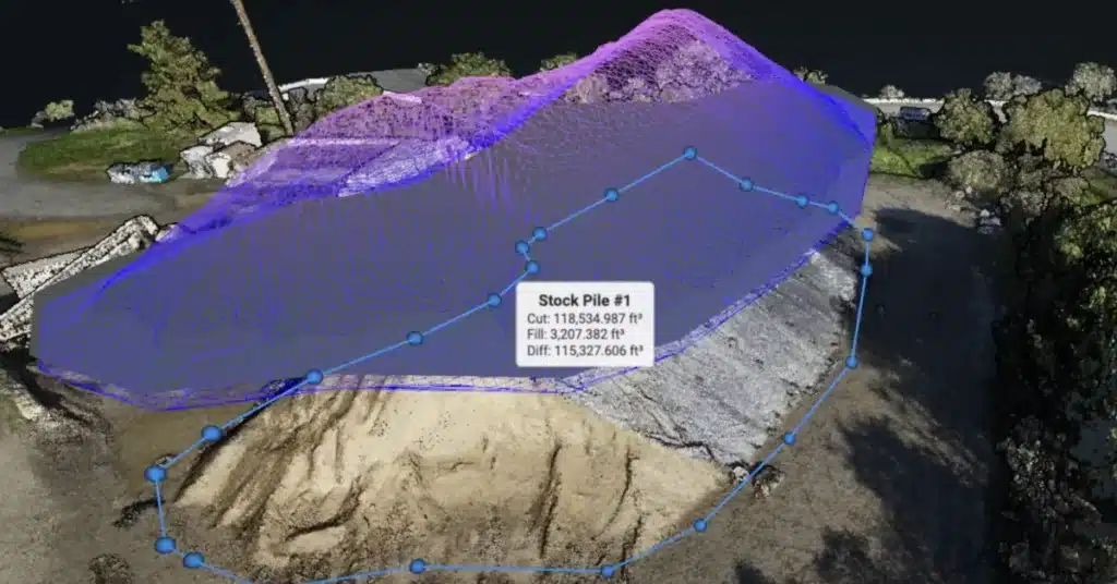
In the mining and quarrying industry, accurate volumetric calculations are essential for resource estimation, inventory management, and operational planning. LiDAR technology allows professionals to efficiently monitor stockpile volumes, track changes over time, and optimize extraction processes. By providing precise 3D data, LiDAR enables better decision-making and improves overall operational efficiency.
Construction and Earthworks
LiDAR-based volumetric calculations play a significant role in construction and earthworks projects. They help in accurately estimating cut and fill volumes, monitoring progress, and validating completed work. With LiDAR’s high-resolution data, construction professionals can easily identify discrepancies and make necessary adjustments, ensuring the project stays on schedule and within budget.
Landfill Management
Landfill operators rely on accurate volumetric data to monitor available airspace, plan expansions, and comply with regulations. Drone-based LiDAR surveys provide an efficient method for collecting high-resolution data, enabling landfill managers to track changes in waste volumes and make informed decisions about landfill operations.
Agriculture and Forestry
Volumetric calculations using LiDAR technology have numerous applications in agriculture and forestry, including assessing biomass, monitoring crop growth, and estimating forest resources. By providing detailed 3D data, LiDAR can help farmers and foresters make informed decisions about land management, resource allocation, and conservation efforts.
Comparing LiDAR to Traditional Surveying Methods
LiDAR vs. Traditional Surveying for Volumetric Measurement
While traditional surveying methods, such as photogrammetry and ground-based surveys, have been used for volumetric measurements for many years, LiDAR technology offers several advantages:
| Method | LiDAR | Traditional Surveying |
|---|---|---|
| Accuracy | High accuracy (up to 10-15 cm) | Lower accuracy, susceptible to human error |
| Speed | Rapid data collection and processing | Slower data collection and processing |
| Safety | Reduces risk by minimizing ground personnel | Greater risk due to ground personnel involvement |
| Terrain | Effective in complex terrain | Limited effectiveness in complex terrain |
| Data Density | High-resolution, dense point clouds | Lower resolution, less dense data |
| Environmental Impact | Minimal disruption to the environment | Greater disruption due to ground-based measurements |
Monitoring Stockpile Volumes with LiDAR
Monitoring stockpile volumes is crucial for various industries, including mining, quarrying, and construction. LiDAR technology offers a more efficient and accurate method for measuring stockpile volumes compared to traditional surveying techniques. By collecting high-resolution 3D data, LiDAR allows professionals to monitor changes in stockpile volumes over time, optimize resource allocation, and make informed decisions about inventory management.
Challenges and Limitations of LiDAR-based Volumetric Calculations
Despite the numerous advantages of using LiDAR technology for volumetric calculations, there are a few challenges and limitations to consider:
Weather Conditions
LiDAR technology can be sensitive to weather conditions, such as rain, fog, or heavy snow. These conditions may affect the accuracy of the data collected and, in some cases, prevent the LiDAR system from working correctly. To ensure accurate results, it is essential to plan LiDAR surveys during favorable weather conditions.
Vegetation and Surface Materials
Dense vegetation and certain surface materials can impact the accuracy of LiDAR data. For example, thick foliage may partially obstruct the laser pulses, leading to incomplete or inaccurate point clouds. In such cases, additional ground control points or supplementary data collection methods may be necessary to improve the accuracy of volumetric calculations.
Cost and Accessibility
While the cost of LiDAR technology has decreased significantly in recent years, it can still be relatively expensive, especially for small-scale projects or businesses with limited budgets. Additionally, access to high-quality LiDAR equipment and trained personnel may be a challenge in some areas.
Software Options for Processing LiDAR Data for Volumetric Calculations
To make the most of LiDAR-generated data, professionals need to rely on specialized software for processing and analyzing the information. Several software options are available in the market, each offering different features and capabilities. Some popular LiDAR processing software options include:
Global Mapper
Global Mapper is a versatile GIS software that supports LiDAR data processing and analysis. With built-in tools for terrain analysis, volumetric calculations, and 3D visualization, Global Mapper is a powerful solution for professionals working with LiDAR data.
Esri ArcGIS
Esri’s ArcGIS suite is a widely-used GIS software platform that offers comprehensive tools for LiDAR data processing and analysis. ArcGIS includes advanced features for volumetric calculations, terrain modeling, and 3D visualization, making it a popular choice among industry professionals.
CloudCompare
CloudCompare is an open-source 3D point cloud and mesh processing software that supports LiDAR data. It offers various tools for editing, filtering, and analyzing point clouds, making it a suitable option for those looking for a cost-effective solution for LiDAR data processing.
LASTools
LASTools is a collection of command-line tools designed specifically for processing LiDAR data. It offers a range of features for data filtering, classification, and conversion, making it a powerful and efficient option for professionals working with large LiDAR datasets.
When selecting the appropriate software for processing LiDAR data, it is essential to consider factors such as budget, ease of use, and compatibility with existing workflows and software platforms.
Industry-specific Use Cases and Best Practices
Volumetric Measurement with LiDAR in Construction
LiDAR technology has proven to be invaluable in the construction industry, especially for volumetric measurements. Here are some specific use cases and best practices for using LiDAR in construction:
- Cut and fill calculations: By accurately measuring the volume of material that needs to be excavated or added to a construction site, LiDAR helps optimize project planning, resource allocation, and cost estimation.
- Earthwork monitoring: LiDAR can be used to monitor earthwork progress, compare it to the design plans, and identify any deviations that may require corrective action.
- Stockpile management: Regular LiDAR surveys of stockpiles help track material consumption and manage inventory levels, ensuring the timely availability of resources.
Best Practice: To maximize the benefits of LiDAR technology in construction, it is essential to plan and execute regular drone surveys, establish proper ground control points, and use compatible software for data processing and analysis.
LiDAR Volumetric Calculation in Mining
In the mining industry, accurate volumetric calculations are crucial for various operational and financial purposes. Here are some specific use cases and best practices for using LiDAR in mining:
- Resource estimation: By measuring the volume of mineral deposits, LiDAR helps estimate the resources available for extraction, informing mine planning and investment decisions.
- Stockpile management: Regular LiDAR surveys enable mining companies to monitor stockpile volumes and optimize resource allocation, reducing operational costs and increasing efficiency.
- Reclamation planning: LiDAR data can be used to plan and monitor land reclamation efforts, ensuring compliance with environmental regulations and minimizing the impact of mining activities.
Best Practice: In mining, it is vital to ensure that LiDAR data is collected and processed using standardized procedures and industry-specific software to maintain consistency and reliability in volumetric calculations.
Tips for Accurate Volumetric Calculations using LiDAR
To ensure the highest accuracy in volumetric calculations with LiDAR, consider the following tips:
- Use high-quality LiDAR equipment: The quality of your LiDAR equipment has a direct impact on the accuracy of your data. Invest in high-quality sensors and drones to achieve the best results.
- Plan your LiDAR survey carefully: Consider factors such as weather, site accessibility, and vegetation when planning your LiDAR survey to minimize potential data inaccuracies.
- Establish proper ground control points: Use ground control points to improve the accuracy of LiDAR data by providing a reference for georeferencing and data validation.
- Process and analyze data with suitable software: Choose the right software for processing and analyzing LiDAR data, considering factors such as compatibility, ease of use, and available features.
- Regularly update your data: Conduct regular LiDAR surveys to keep your volumetric data up-to-date, ensuring that your calculations remain accurate and relevant.
By following these best practices, you can optimize the use of LiDAR technology for volumetric calculations and achieve the highest possible accuracy in your projects.
Partnering with Blue Falcon Aerial for Expert Volumetric Calculations with LiDAR
When it comes to volumetric calculations with LiDAR, partnering with a professional and experienced service provider like Blue Falcon Aerial is the key to success. With their expertise in LiDAR technology and a proven track record in delivering high-quality results, Blue Falcon Aerial is the ideal partner for all your LiDAR-based volumetric calculation needs.
How Blue Falcon Aerial Can Help
Blue Falcon Aerial specializes in providing LiDAR services that cater to a wide range of industries, including mining, construction, agriculture, and more. Their team of experts uses the latest drone-based LiDAR technology to capture high-resolution 3D data, ensuring accurate and efficient volumetric calculations.
By partnering with Blue Falcon Aerial, you can benefit from their in-depth knowledge and experience in handling complex LiDAR projects, allowing you to focus on your core business operations while they take care of the technical aspects.
Comprehensive Deliverables Offered by Blue Falcon Aerial
Blue Falcon Aerial is committed to delivering high-quality results that exceed their clients’ expectations. Their comprehensive deliverables include:
- High-resolution aerial imagery
- Accurate and detailed 3D point clouds
- Digital terrain models (DTMs) and digital surface models (DSMs)
- Volumetric calculations and reports
- Contour maps and profiles
- Topographic maps
- 3D models and visualizations
These deliverables can be customized to meet your specific project requirements and provide valuable insights that facilitate informed decision-making.
In conclusion, LiDAR technology has revolutionized volumetric calculations, offering unparalleled accuracy, efficiency, and safety compared to traditional surveying methods. By partnering with Blue Falcon Aerial for your LiDAR-based volumetric calculation needs, you can leverage their expertise and advanced technology to achieve the best possible results. To learn more about how Blue Falcon Aerial can help you with your next project or to request a quote, contact them today.