In an era where the impact of human activity on the environment is a central concern, Environmental Impact Assessments (EIAs) have become increasingly important. However, traditional methods of conducting EIAs are often time-consuming, costly, and limited in scope. This is where modern technologies, particularly orthomosaic drones, come into play. They’re revolutionizing the field, offering detailed, accurate results while dramatically reducing both time and cost. Drone mapping, geospatial analysis, remote sensing techniques, and the integration of orthomosaics with GIS are transforming environmental impact assessments. This article will explore these technologies, focusing on how orthomosaics are used in environmental impact assessments, the benefits they offer, and how they can help identify potential environmental risks.
Increased Necessity for Environmental Impact Assessments
In the face of global expansion and rampant development, Environmental Impact Assessments (EIAs) have emerged as an imperative tool. These EIAs address the potential environmental repercussions that new developments might engender.
Utilizing Orthomosaic Technology in EIAs
Within the EIA framework, orthomosaic technology has become a notable instrument. This cutting-edge technology enables the production of expansive, precise maps derived from aerial imagery. These comprehensive images supply essential data, paving the way for a more profound understanding of possible environmental implications linked to proposed projects.
| Technological Approach | EIA Function |
|---|---|
| Orthomosaic | Facilitates the creation of precise maps and images for analysis, crucial for identifying potential areas of environmental impact |
Deciphering Environmental Impact Assessments
An appreciation for EIAs—their method and relevance—can promote informed choices. At its core, an EIA is a procedural tool that scrutinizes the environmental consequences affiliated with a proposed project prior to making decisions.
The Scope and Objective of EIAs
An Environmental Impact Assessment (EIA) is the analysis of the prospective environmental effects a proposed project or development might induce. The primary objective of conducting an EIA is to guarantee that the environmental implications are considered by decision-makers before deciding to move forward with a project.
EIA’s Importance in Contemporary Society
In today’s world, burdened with mounting environmental dilemmas, the EIA has become a critical tool. It facilitates a balance between development demands and environmental preservation.
| Environmental Dilemmas | EIA’s Function |
|---|---|
| Climate Change | EIAs examine a project’s carbon footprint and offer mitigation tactics |
| Loss of Biodiversity | EIAs recognize impacts on local plant and animal species and suggest protective measures |
| Land Degradation | EIAs scrutinize impacts on soil and land quality and propose recuperative strategies |
Role of Geospatial Analysis in Environmental Impact Assessments
In the context of EIAs, geospatial analysis is of paramount importance. By placing data in a spatial context, we can obtain a richer understanding of potential environmental implications and devise more potent mitigation strategies.
Drones in the Realm of Environmental Impact Assessments
Unmanned Aerial Vehicles (UAVs) or drones have emerged as a significant component of the EIA process. Drones are a cost-efficient and effective way of gathering high-quality, detailed data over a broad area. This data can then be used for a comprehensive analysis of the possible environmental implications of a proposed project.
Deploying Drones in Environmental Impact Assessments
The utility of drones in Environmental Impact Assessments (EIAs) extends far beyond basic reconnaissance. These high-tech tools can gather extensive and nuanced data to facilitate comprehensive environmental analyses.
Drone Mapping for Environmental Impact Assessments
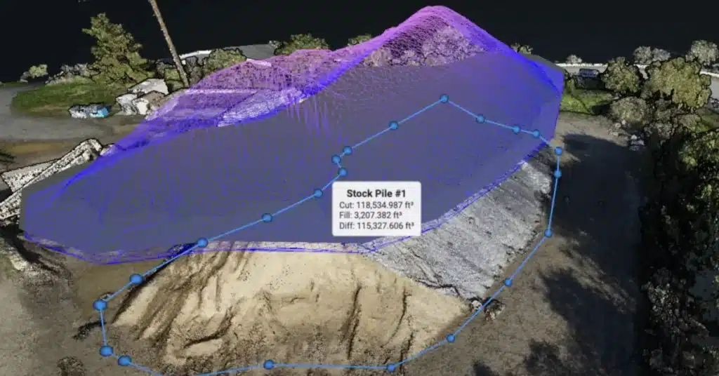
Drone mapping provides a robust methodology for Environmental Impact Assessments. This involves using drones equipped with advanced imaging technologies to collect spatial data of the project area. The resultant high-resolution maps and 3D models provide valuable visual and spatial data that inform critical elements of the assessment.
| Mapping Technique | Benefits in EIA |
|---|---|
| Drone Mapping | Produces high-resolution maps and 3D models, assists in identifying potential environmental impacts |
Regulations and Guidelines for Using Drones in Impact Assessments
As drone technology continues to advance, numerous regulations and guidelines have been implemented to ensure their safe and ethical use. These stipulations encompass flight altitude limitations, restricted areas, and data privacy concerns, among others. Compliance with these regulations is essential for the legitimacy and reliability of drone-assisted EIAs.
Understanding Orthomosaic Technology
Orthomosaic technology plays a key role in modern environmental impact assessments. It provides a unique approach to data gathering and analysis, offering highly detailed and accurate visual information.
Explanation of Orthomosaic Technology
Orthomosaic technology refers to a process where multiple aerial images are stitched together to create a single, highly detailed, and geospatially accurate map. Each pixel in an orthomosaic image contains geospatial data, making these maps a powerful tool for environmental analysis.
| Term | Definition |
|---|---|
| Orthomosaic | A highly detailed, geospatially accurate map created by stitching together multiple aerial images |
Orthomosaic Techniques for Ecological Impact Assessments
In the context of ecological impact assessments, orthomosaic techniques offer several distinct advantages. They provide an accurate representation of an environment, enabling comprehensive analyses of habitats, species distribution, landscape changes, and more.
Interpreting Orthomosaic Data for Impact Assessment Purposes
The interpretation of orthomosaic data is an essential skill in impact assessments. With the right tools and training, analysts can extract valuable insights about environmental changes and potential impacts from these detailed maps.
Why Orthomosaic for Environmental Impact Assessments
The adoption of orthomosaic technology in EIAs is driven by its accuracy, detail, and the extensive scope of insights it can provide. It is particularly useful in areas that are difficult to access or cover large geographical scales. By offering a precise and comprehensive view of the environment, orthomosaic technology enhances the effectiveness and accuracy of environmental impact assessments.
In-depth Analysis of Orthomosaic Use in EIAs
The role of orthomosaic technology in Environmental Impact Assessments (EIAs) cannot be overstated. This technology provides high-resolution, georeferenced images that form a comprehensive and precise map of the area under review, adding significant value to the assessment process.
Benefits of Orthomosaics in Impact Assessments
The highly detailed nature of orthomosaics provides several benefits for environmental impact assessments. Among these are improved identification of potential environmental impacts, effective tracking of changes over time, and more efficient data gathering processes.
| Orthomosaic Benefits | Impact on EIAs |
|---|---|
| Detailed visualization | Enables the identification of fine environmental details |
| Geospatial accuracy | Assists in precise tracking and location of potential impacts |
| Time efficiency | Facilitates quicker data gathering and analysis |
Orthomosaics Identifying Potential Environmental Risks
Orthomosaics are particularly effective at identifying potential environmental risks. By providing an intricate and highly accurate visual representation of the project area, orthomosaics can help identify delicate habitats, endangered species locations, and areas of potential erosion or contamination, among other concerns.
Integration of Orthomosaics and GIS in Environmental Assessments
The integration of orthomosaic technology with Geographic Information Systems (GIS) enhances the potential of both technologies, providing a comprehensive tool for environmental impact assessments.
Understanding the Synergies between Orthomosaics and GIS
Orthomosaics and GIS have significant synergies when used together. Orthomosaic images provide detailed, georeferenced data that can be directly imported into a GIS for further analysis. This combination allows for a more profound understanding of environmental impacts, as well as for precise tracking of changes over time.
| Technology | Synergies with GIS |
|---|---|
| Orthomosaic | Provides detailed, georeferenced data that can be incorporated into GIS for further analysis |
Best Practices for Using Orthomosaics in Environmental Impact Assessments
To ensure the effective use of orthomosaics in EIAs, several best practices should be followed. These include maintaining high data quality, verifying geospatial accuracy, and integrating orthomosaics effectively with other data sources and technologies.
Guidelines for Acquiring Accurate Orthomosaic Data for Impact Assessments
Acquiring accurate orthomosaic data requires careful planning and execution. Key guidelines include flying drones at an appropriate altitude to capture high-resolution images, ensuring good lighting conditions for image capture, and using appropriate software to stitch together and analyze the orthomosaic images.
Orthomosaic Applications in Ecological Assessments
The field of ecological assessment is increasingly benefiting from the use of orthomosaic technology. Integrated with remote sensing techniques, it opens up new opportunities to detect, analyze, and monitor environmental impacts.
Remote Sensing Techniques for Environmental Impact Assessments
Remote sensing techniques used in environmental impact assessments have been revolutionized by the introduction of orthomosaic technology. This technology, when paired with drones, provides researchers with a means to gather high-resolution, geospatially accurate data from the air.
| Remote Sensing Technique | Utility in EIAs |
|---|---|
| Orthomosaic Technology | Facilitates collection of high-resolution, geospatially accurate data |
Case Studies of Orthomosaic Applications in Environmental Impact Assessments
The effectiveness of orthomosaic technology in environmental impact assessments can be evidenced through various case studies. These range from monitoring deforestation in the Amazon to tracking habitat restoration efforts in wetland areas. Each instance demonstrates the invaluable contribution of orthomosaics in facilitating a detailed, accurate, and efficient assessment of environmental impacts.
Future of Environmental Impact Assessments: Role of Orthomosaic Drones
As we move forward, the integration of orthomosaic technology and drones will increasingly shape the future of Environmental Impact Assessments. Their ability to capture high-resolution, geospatially accurate images makes them a potent tool for these critical analyses.
Future Trends and Predictions
In the future, the application of orthomosaic drones in EIAs is expected to become even more prevalent. Technological advancements are likely to further enhance their capacity for data collection and analysis. We may also see increased integration with other technologies, such as artificial intelligence (AI), to augment the analysis of orthomosaic data.
| Future Trend | Impact on EIAs |
|---|---|
| Technological Advancements | Enhanced data collection and analysis |
| Integration with AI | Augmented analysis of orthomosaic data |
In this article, we’ve explored the significant role of orthomosaic technology in conducting Environmental Impact Assessments. We delved into the process of drone mapping, the interpretation of orthomosaic data, the synergies between orthomosaics and GIS, and the many benefits of these technologies. Furthermore, we shed light on the guidelines for using drones and orthomosaics in environmental impact assessments, including the acquisition of accurate data.
If you’re eager to delve deeper into the world of drone photogrammetry and orthomosaics, we recommend our Ultimate Guide to Drone Photogrammetry and Orthomosaics. The guide offers a comprehensive understanding of this rapidly evolving technology that is shaping the future of environmental impact assessments