
Blue Falcon Aerial's Deliverables
Ensuring Precision with Rock Cloud
Rock Cloud: Premium LiDAR Data Management Solution
At Blue Falcon Aerial, we’ve partnered with Rock Robotic to harness the power of Rock Cloud, a revolutionary LiDAR data management system. Rock Cloud stands out as a secure, scalable, and rapid solution for LiDAR data processing and delivery. Our collaboration focuses on three core deliverables, each tailored to meet the diverse needs of our clients.
1. Rock Surveyor:
- Purpose: Provides detailed ground topography insights.
- Applications: Versatile for various industries including construction, roadway development, and land surveying.
- Benefit: Enhances project accuracy and efficiency.
2. Vegetation Management:
- Objective: Assesses vegetation around power lines and transmission corridors.
- Significance: Ensures safety and reliability in power distribution.
- Advantage: Aids in preventing potential hazards and service interruptions.
3. Planimetrics:
- Function: Offers a two-dimensional representation of geographic features.
- Industry Use: Diverse applications across multiple sectors.
- Value: Facilitates better planning and decision-making.
Quality Assurance: Every deliverable undergoes rigorous manual quality control. This process guarantees results that are not only accurate but also reliable, aligning with our commitment to excellence.
Introducing Rock Cloud by Rock Robotic:
- Innovation: Developed by Rock Robotic, Rock Cloud is a cutting-edge, cloud-based system.
- Design: Specially designed for LiDAR data storage, processing, and delivery.
- User Experience: Offers a user-friendly environment, making data management effortless and efficient.
- Industry Range: Ideal for a wide array of industries, enhancing their capability to manage LiDAR data effectively.
This partnership and these deliverables reflect our mission to make LiDAR accessible to every surveyor, regardless of project size. By democratizing advanced LiDAR technology, we empower our clients to stay ahead in their field, blending efficiency, cost-effectiveness, and innovation.
Speed and Accuracy: Transformative Real-Time Data Processing
Rock Cloud redefines LiDAR data management with its speed and precision. This system is a game-changer for critical applications such as:
- Emergency response: Delivering data when every second counts.
- Environmental monitoring: Enabling swift, informed decisions.
- Infrastructure development: Streamlining project execution.
Real-time data processing is essential for these areas, ensuring accuracy and timeliness in every project.
Scalability: Tailored to Evolve with Your Needs
Rock Cloud’s scalability sets it apart. It’s designed to adapt to growing data demands, making it a long-term solution for:
- Expanding data storage: Without constraints on capacity.
- Increasing processing power: Adapting to evolving requirements.
This adaptability is crucial, offering a future-proof solution for organizations of all sizes.
Security: Uncompromising Data Protection
At the heart of Rock Cloud is robust security:
- Data confidentiality: Ensuring sensitive information stays protected.
- Encryption protocols: Guarding against unauthorized access.
- Access control tools: Offering clients complete management of data permissions.
This comprehensive security approach assures that your data is always safe and secure.
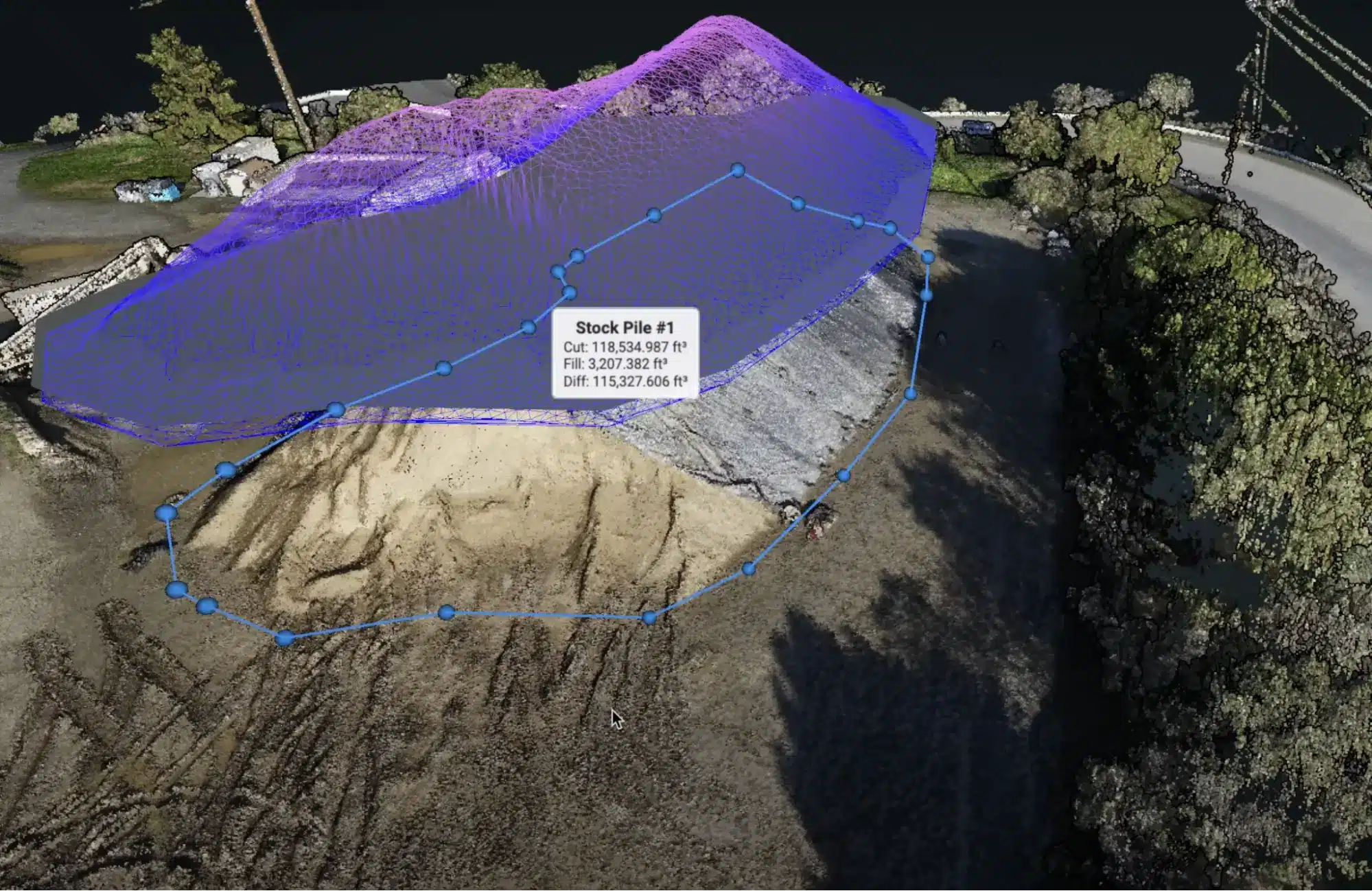
Precision and Efficiency: Advanced Measurement Capabilities
Rock Cloud excels in precision and efficiency with its state-of-the-art tools, ideal for:
- Accurate measurements: Utilizing advanced algorithms and machine learning.
- Stockpile analysis: Enhanced by stringent quality control.
These features enable detailed 3D point cloud generation, crucial for various industries in making informed decisions and improving project outcomes.
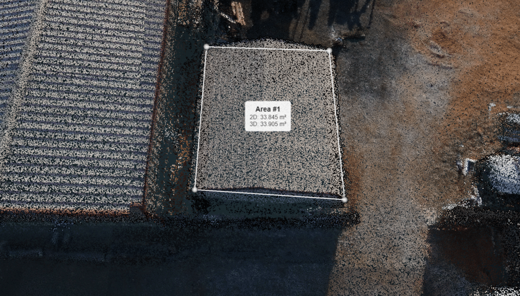
Versatile Measurement Tool: A Multipurpose Asset
The platform’s versatile measurement tool is indispensable across multiple industries, including:
- Construction and mining: For precise project planning.
- Surveying: Ensuring accuracy in every measurement.
It supports various measurement types such as distances, areas, and volumes, making it a comprehensive tool for professionals.
Harness the Power of Rock Cloud
In conclusion, Rock Cloud is not just a platform; it’s a comprehensive LiDAR data management solution. Its unparalleled processing speeds, scalability, and robust security cater to a wide range of applications:
- Environmental monitoring
- Infrastructure development
- Powerline management
- Natural resource management
Embrace Rock Cloud with Blue Falcon Aerial and experience a new era of efficiency and innovation in LiDAR data management.
numbers
Client results
Support Functions
Lorem ipsum dolor sit amet, consectetur adipiscing elit. Ut elit tellus, luctus nec ullamcorper mattis.
Service Operations
Lorem ipsum dolor sit amet, consectetur adipiscing elit. Ut elit tellus, luctus nec ullamcorper mattis.
Supply Chain
Lorem ipsum dolor sit amet, consectetur adipiscing elit. Ut elit tellus, luctus nec ullamcorper mattis.
Precision Ground Topography Solutions
Rock Robotics proudly unveils the Rock Surveyor deliverable, a game-changer in understanding ground topography. This innovative solution is key for numerous applications such as:
- Land Development
- Engineering Projects
- Environmental Studies
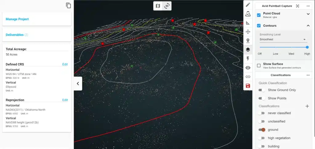
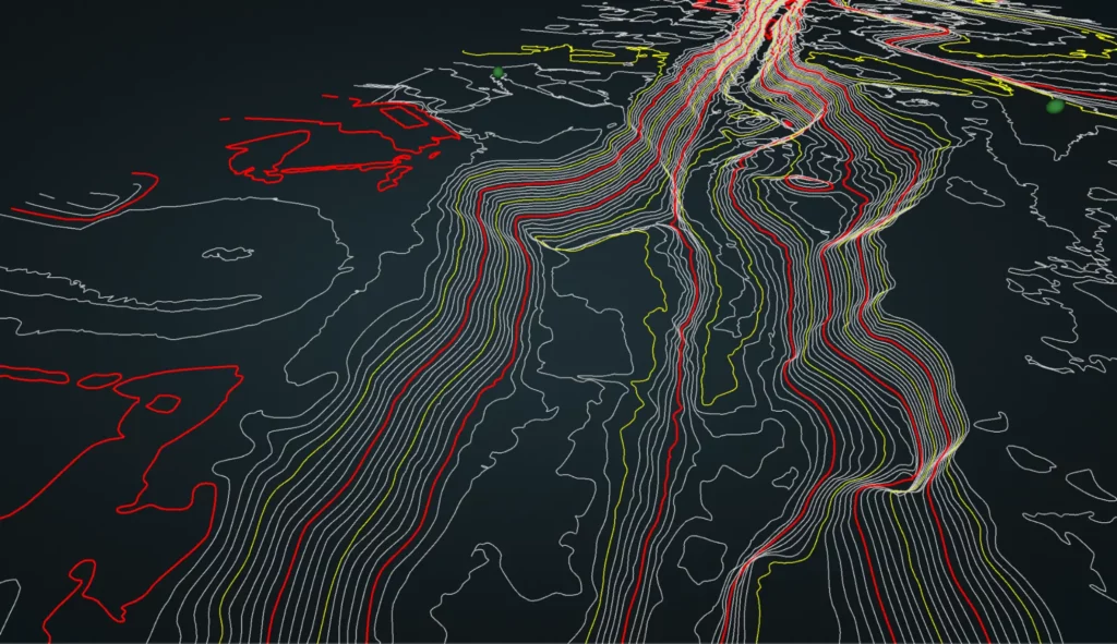
It primarily focuses on generating a Digital Elevation Model (DEM) and Contours, which are vital for precise topographical analysis.
Ground Classification: The Cornerstone of Precision
The journey to accurate deliverables starts with the ground classification via the Rock Cloud AI Engine. This process involves several classification options:
- Ground Only: Basic yet essential.
- Enhanced Classification: Includes Ground, Buildings, and High Vegetation.
- Enhanced Classification Plus: A comprehensive scheme covering Ground, Buildings, Vegetation, Roads, Water, Bridges, and Transmission lines.
This classification step is crucial for filtering out non-ground elements, ensuring the final deliverables’ accuracy. Notably, Rock Cloud accommodates custom LiDAR classification schemes, catering to varied industry needs, from autonomous vehicle companies to utility providers.
Generating DEM and Contours
Following ground classification, we proceed to generate the DEM and contours. These contours are available in popular formats like SHP, DXF, and CSV, ensuring compatibility with any CAD or GIS software. Additionally, users can view these contours directly on the Rock Cloud platform.
Enhancing Contour Accuracy
For even more precision, we offer add-ons such as:
- Breaklines: Enhances elevation data in areas with significant topographical variations.
- Strip Alignment: Improves point cloud accuracy by aligning multiple land strips.
Comprehensive Rock Surveyor Deliverables
Our deliverables package includes:
- Ground Classified laz File: The foundation of our deliverables.
- SHP File: Contains geometry data.
- DBF Attribute Format File: Details attributes of the data.
- SHX Shape Index File: Indexes the shape file.
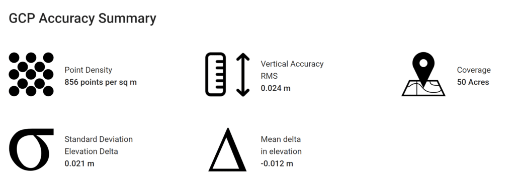
- DEM in TIF Format: Offers a detailed elevation model.
- Accuracy Report: A document detailing the precision and quality of the data. Example of the Accuracy Report.
Rock Surveyor from Rock Robotics is not just a product; it’s an essential tool for anyone needing detailed and accurate ground topography information. It’s versatile, precise, and user-friendly, making it indispensable for a wide array of applications. Explore an Example Rock Surveyor Dataset. to see our precision in action.
The Art of Planimetrics: Crafting Precision in 2D Representation
Planimetrics, a key subfield of cartography, brings to life the two-dimensional representation of various geographic features. These features include roads, buildings, trees, and water bodies, among others. It’s a tool that’s become indispensable across multiple industries:
- Urban Planning
- Civil Engineering
- Environmental Management
- Real Estate
The essence of planimetrics lies in its ability to create detailed and accurate maps, crucial for project planning and development.
ROCK Planimetrics: A Leap in Mapping Technology
ROCK Planimetrics harnesses the power of artificial intelligence and machine learning. This technology guarantees:
- High Accuracy: Precision in every deliverable.
- Quality Control: Ensuring each dataset meets the highest standards.
A standout feature is the cost-effective approach—users can select and pay for only the specific dataset areas they need.

Diverse Applications of ROCK Planimetric Layers
ROCK Planimetric Layers offer a range of physical features for varied uses:
- Urban Planning: Essential for precise area mapping.
- Civil Engineering: Key in infrastructure design and construction.
- Environmental Management: Crucial for conservation planning.
- Real Estate: Enhances accuracy in site planning and marketing.
These layers cover concrete tops and bottoms, footpaths, driveways, buildings, treelines, fences, and manholes, among others.
Conclusion: ROCK Planimetrics – Mapping with Mastery
In conclusion, ROCK Planimetrics from Rock Robotics stands as an essential tool in the world of mapping. It’s not just about creating maps; it’s about crafting them with unparalleled precision and detail. This technology is pivotal across various industries, elevating the standard of 2D geographic representations.
Vegetation Management with LiDAR
A Safety and Reliability Game-Changer
Vegetation management is a critical task for power companies, involving aerial surveys to assess and manage vegetation around power lines and transmission corridors. The goal? To identify and address any vegetation encroachment that poses hazards or risks power outages.
LiDAR Data: The Backbone of Accurate Vegetation Assessment
LiDAR data is pivotal in this process. It generates a detailed 3D point cloud, enabling power companies to:
- Classify vegetation based on height and proximity to power lines.
- Prioritize maintenance to prevent power outages.
- Ensure safety for workers and the public.
This technology is not just about detection; it’s about proactive risk management.
ROCK Vegetation Management: A Comprehensive Approach
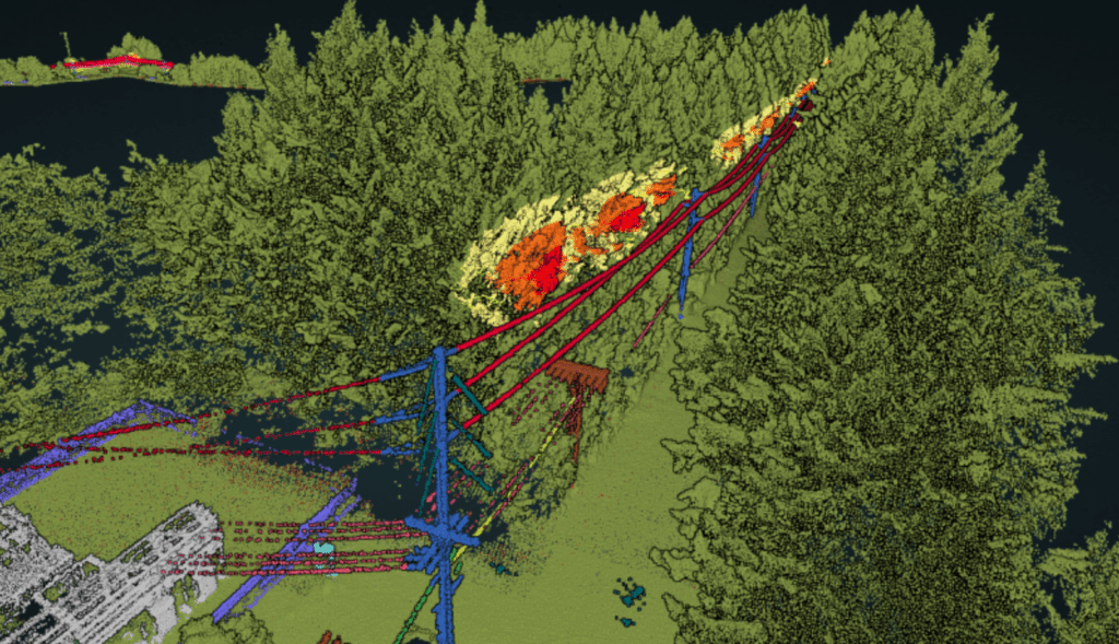
The ROCK Vegetation Management deliverable is designed to offer a complete solution, integrating machine learning, artificial intelligence, and quality control. It provides detailed insights into vegetation encroachments within power line corridors. The deliverable package includes:
- Classified LAS/LAZ File: Accurate depiction of vegetation.
- 3D Polygons: Identify vegetation encroachment zones.
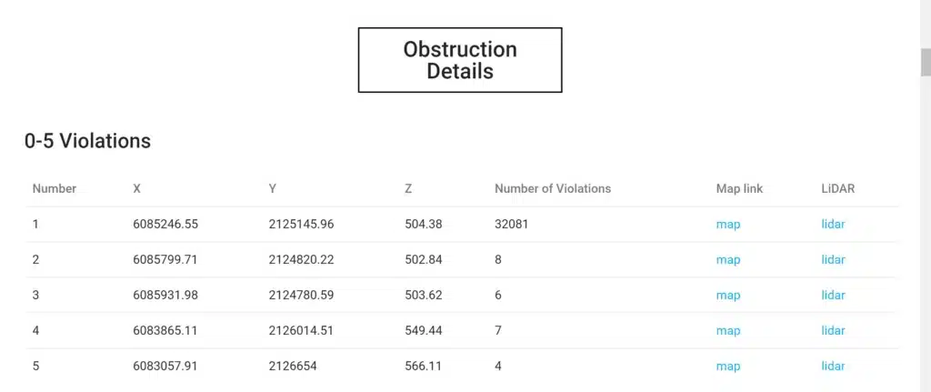
- SHP File: Details specific danger points.
- Obstruction Report: Summarizes overall risk to the corridor.
This comprehensive approach not only highlights risk areas but also guides maintenance prioritization.
Interactive Mapping: Visualizing Danger Points
The SHP file and obstruction report are more than data; they offer a visual understanding of risks. Users can easily:
- Visualize areas of concern.
- Plan maintenance efforts efficiently.
Explore an Example Obstruction Report for an insight into this technology.
LiDAR as a Critical Asset in Vegetation Management
To sum up, LiDAR-based vegetation management is an indispensable tool for power companies. It ensures infrastructure safety and operational reliability. By leveraging LiDAR, risks are not just identified but can be preemptively managed.
Check out this Example Vegetation Management Data.
Get Vegetation Management Deliverables with Blue Falcon Aerial
Interested in leveraging these advanced vegetation management solutions? Contact Blue Falcon Aerial. Their team offers tailored LiDAR data solutions, ensuring your power infrastructure’s safety and reliability. Reach out today and harness the power of LiDAR technology for your vegetation management needs.
Learn more
Frequently Asked Questions
Aerial lidar is commonly used in the construction industry for tasks such as creating digital terrain models, measuring volumes of stockpiles and cut/fill areas, and identifying potential issues with a construction site before work begins.
Aerial lidar (light detection and ranging) is a remote sensing method that uses laser technology to measure the distance to a target. It differs from other forms of remote sensing such as photogrammetry and radar in that it can collect high-resolution, precise 3D data in a relatively short amount of time.
Aerial lidar measurements can be extremely accurate, with typical horizontal and vertical accuracy levels of less than 10 cm. The level of accuracy is dependent on factors such as the density of the point cloud data collected and the quality of the sensor used.
Orthomosaic is a type of mosaic that has been geometrically corrected to minimize distortion and ensure that each pixel represents the same ground area throughout the image. A regular mosaic is a composite image made up of several overlapping images, but it does not have the same geometric correction.
Orthomosaics can be used in construction for tasks such as creating accurate maps, measuring distances and areas, and identifying potential issues with a construction site. They can also be used to monitor progress on a construction site over time.
To ensure that data obtained from aerial lidar and orthomosaics is accurate, it is important to use high-quality sensors and to properly process the data using specialized software. Additionally, ground control points can be used to accurately align the data with known coordinates.
GET IN TOUCH
Contact us today to schedule an online or in person demo!
High-Fidelity Orthomosaic Mapping
Experience a transformative view with our Orthomosaic Mapping. We masterfully combine multiple aerial images to create a unified, highly accurate representation. This comprehensive imagery offers precision and clarity, essential for informed decision-making.

Advanced Aerial LiDAR Mapping
Embrace the cutting-edge of remote sensing technology with Blue Falcon Aerial. Our LiDAR mapping services employ laser pulses to generate intricate 3D point clouds. This technology transforms complex terrains into clear, actionable data, propelling your projects towards success.
Drone Technology Integration Services
Customized solutions to seamlessly integrate drones into your existing business workflows, enhancing efficiency and decision-making with advanced mapping, 3D modeling, and comprehensive team training.